Geospatial Data Visualizer and Converter KML,KMZ,SHP,DXF,DAT (SHP to KML).

Geospatial Technlogies WEB APP
GIS TOOLS
User Guide: Utilizing the Geospatial Web Application
Welcome to your geospatial web application! This guide will help you navigate and utilize the powerful features designed to manage and visualize geospatial data effectively.
1. Account Access
- Sign In: Click the "Sign In" button to access your account. This ensures a personalized experience tailored to your geospatial projects.
2. Interactive Map
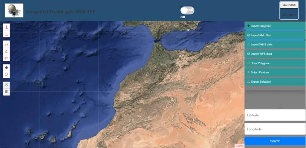
- The central map container allows you to visualize and interact with various geospatial datasets. Use this map to explore and analyze data spatially.
3. Data Management Tools
- Import Options:
- Import Shapefile: Click to upload SHP files directly. This feature allows you to bring in vector data for analysis.
- Import KML: Easily import KML files to integrate additional geographic data.
- Import WMS/WFS: Use these options to import web map services and feature services, adding dynamic layers to your map.
- Drawing Tools:
- Draw Polygon: Use this feature to create custom polygons on the map for your area of interest.
- Select Feature: Activate this mode to click and select features on the map for detailed analysis.
- Export Functionality:
- Export Selection: After selecting features, use this option to export them as Shapefiles for future use or sharing.
4. GeoData Conversion Features

- Convert various data formats to enhance interoperability:
- DAT to SHP: Easily convert DAT files to Shapefiles.
- SHP to KML: Easily convert SHP files to KML format.
- KMZ to SHP: Easily convert KMZ files to Shapefiles.
- CAD to SHP: Import CAD files and convert them to Shapefiles.
- SHP to DXF: Convert Shapefiles to DXF format for compatibility with CAD software.
5. Coordinate Search
- Search Coordinates: Input latitude and longitude directly into the search bar. This feature helps you locate specific points on the map quickly.
6. Responsive Modals
- WMS and WFS Import Modals: These pop-up windows guide you in entering URLs and layer names to import additional data layers seamlessly.
Conclusion
This geospatial web application offers an intuitive interface combined with robust functionalities to support your geospatial analysis needs. Explore the features, import your data, and take full advantage of the tools available to enhance your projects!
Another platform available provides similar map viewer for free, with advanced functionalities : ArcGIS Online.
Table of Contents
See our articles about Geospatial Mapping.
