Deep Learning for Geospatial Image Classification – Training Models
Deep Learning for Geospatial Image Classification – Training Models
Deep Learning for Geospatial Image Classification – Training Models
As our planet faces the challenges of sustainable development and environmental protection, understanding and analyzing geospatial data becomes increasingly crucial. Geospatial artificial intelligence (GeoAI) utilizes deep learning techniques to meet the growing need for intelligent analysis of Earth observation satellite imagery and other spatial information sources. In this blog post, we’ll explore the fascinating world of training deep learning models for geospatial image classification.
What is GeoAI?
GeoAI encompasses the application of artificial intelligence (AI) techniques to geospatial data. This innovative approach leverages the power of deep learning algorithms and computer vision to process and analyze large volumes of geographic data, extracting valuable insights for diverse applications.
Key Features of GeoAI:
- Data Richness and Complexity: GeoAI excels at dealing with the vast and diverse nature of geospatial data, encompassing diverse formats, resolutions, and sensor types. It’s ideal for analyzing satellite imagery, aerial photos, lidar scans, and other geospatial data formats.
- Spatial Features: Equipped with advanced spatial learning methods, GeoAI can effectively identify and analyze spatial patterns and relationships within data, revealing geographical insights and trends.
- High-Resolution Data Analysis: This method makes advanced image recognition and classification possible, as it can analyze precisely how objects and phenomena relate to their spatial context within an image.
- Automated Processes and Insights: GeoAI automates complex data processing tasks, such as categorization, detection, and monitoring, enabling quicker analysis and more informed decisions.
Benefits of Using Deep Learning for Geospatial Image Classification
Deploying deep learning methods for image classification brings numerous advantages for geospatial analysis:
- Improved Accuracy: Deep learning architectures excel at identifying subtle patterns and features, leading to more accurate classification results.
- Increased Efficiency: These models can process large datasets and automate complex image analysis tasks more efficiently than traditional methods.
- Robustness: Deep learning models offer greater robustness to variations within real-world data, for instance, surface undulation that causes artifacts in optical and lidar images.
- Scalability: The underlying layers of these specific algorithms allow for training on vast data resources, readily adapting to new and expanding datasets.
- Continuous Learning: Models benefit from continuous learning and data enhancements, facilitating progressive improvements as they are exposed to new information.
Practical Applications of Deep Learning in GeoAI
The applications of deep learning for geospatial image classification are truly diverse and impactful:
- Agriculture: Precise crop mapping and planning for crop yield optimization.
- Forestry: Monitoring forest health, identifying areas of deforestation, and combating forest fire threats.
- Natural Resources: Land use mapping, biodiversity analysis, and detecting oil spills and illegal mining.
- Urban Planning: Design efficient infrastructure and urban planning considering the needs and characteristics of various neighborhoods.
- Disaster Management: Identifying affected areas for disaster response, monitoring flood and wildfire progress.
- Traffic Monitoring: Analyzing traffic patterns, identifying congestion hotspots, and optimizing transportation infrastructure.
Training Your Own Deep Learning Models
Training a deep learning model for geospatial classification involves these key steps:
- Data Acquisition: Gather and curate geospatial data related to your target classification. Employ a high-quality dataset tailored to your specific application.
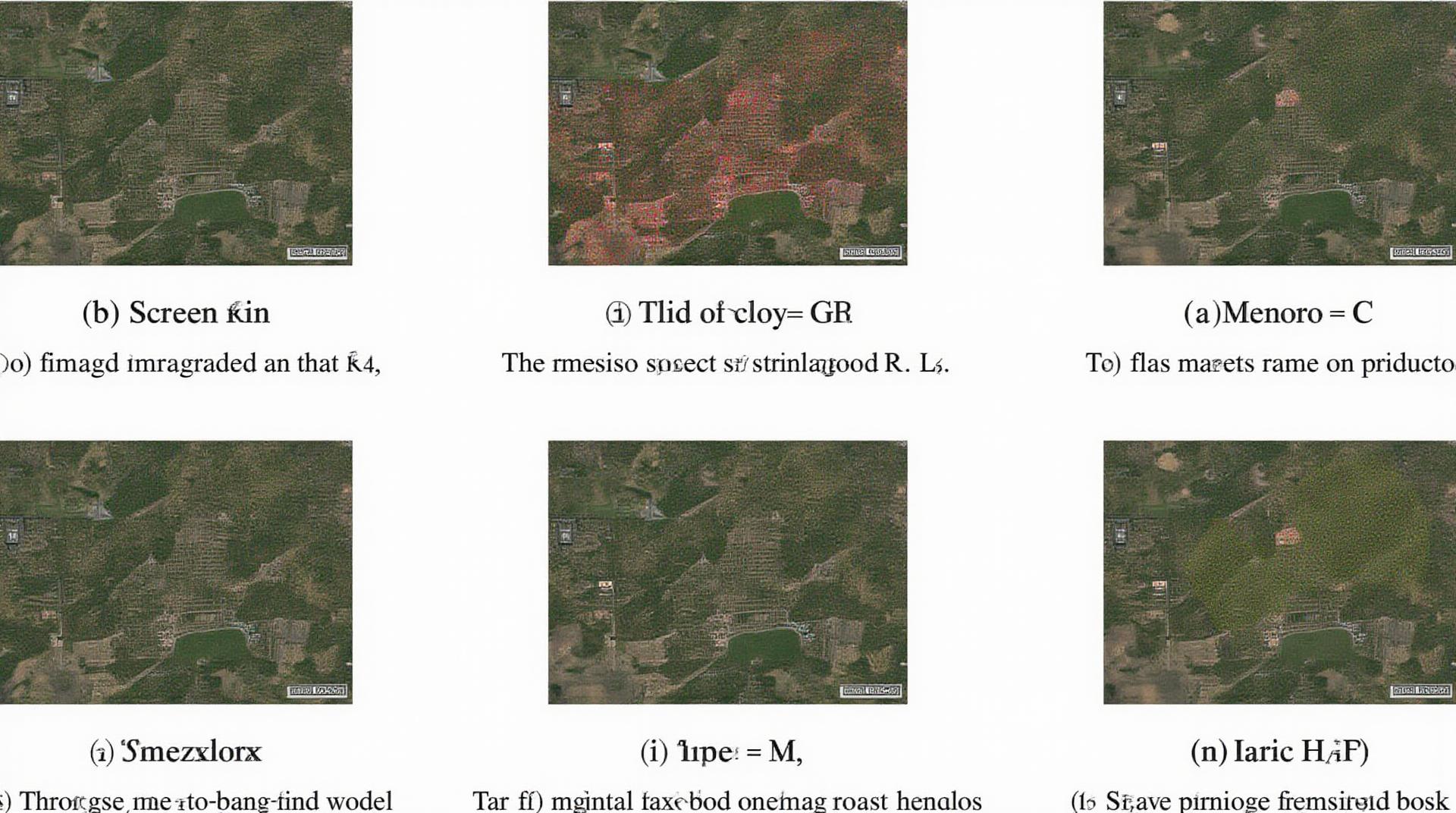
- Preprocessing: Normalize and adapt your dataset for training. Surface feature adaption and image masking (e.g. for individual buildings, forest canopies, etc.) notes.
- Model selection & Selection: ** Choose an appropriate deep learning model architecture:
* For basic classification like buildings, you might consider a 2D convolutional neural network (CNN).
* For more sophisticated scenario mapping, like vegetation types and land use changes, you might opt for a multi-scale, 3D convolutional architecture (e.g., U-Net or SegNet). - Training & Fine-tuning: ** Implement the selected model design, training data, and metrics for evaluation.
* Experiment with hyperparameters to optimize model performance on your chosen task by exploring historical efficiency trends.- Evaluation: ** Define evaluation metrics for your classification model, such as precision, recall, F1-score, and Area Under the Curve (AUC).
Key Resources for Learning More
Interested in delving deeper into Geographic AI and deep learning? Here are some resources to help you get started:
- Deeplearning.ai Courses: Offers courses focusing on image classification and deep learning fundamentals.
- AI for Earth: A program focused on Earth Observation data analysis, utilizing several deep learning techniques.
- GeoAITools: Offers point-in-time material for those working in the field of GeoAI.
- Kaggle Competitions: ** Search for datasets relevant to your niche, data processing, and model-building.
Conclusion
As technology advances, GeoAI solutions are enabling efficient, accurate, and scalable analysis of geospatial data. With the power of deep learning creeping into every aspect of our world, geospatial developers and analysts are at the forefront, driving growth and contributing to a sustainable future.
## Deep-Learning-Geospatial-Image-Classification: FAQs
This section addresses common questions about deep-learning-geospatial-image-classification.
What is deep-learning-geospatial-image-classification?
Deep-learning-geospatial-image-classification uses artificial intelligence and deep learning algorithms to automatically analyze and categorize geospatial images. These images are often satellite or aerial photos that provide valuable data for various purposes, such as:
* **Land-use mapping:** Identifying how farmland, forests, and urban areas change over time.
* **Environmental monitoring:** Detecting natural disasters, monitoring pollution, and tracking deforestation.
* **Disaster response:** Assessing damage and providing information for relief efforts.
* **Crop management:** Examining plant health and identifying optimal planting strategies.
I want to try deep-learning-geospatial-image-classification, what do I need to know?
To get started, you need:
* **Data:** You’ll need labeled geospatial images, with each image categorized (e.g., forest, water, urban), for training your deep-learning model.
* **Hardware:** Training a deep-learning model can be computationally demanding. You might need a powerful computer or access to cloud computing resources.
* **Specific software tools:** Libraries like TensorFlow or PyTorch are essential for building and training your model. You could explore cloud-based platforms like Google Colab for easier training.
What types of data are commonly used?
> Common data formats for geospatial images include:
* **Multispectral Imagery (MS):** Sar images offering information across different spectral bands (e.g. red, green, blue, near infrared, shortwave infrared, etc.).
* **Hyperspectral Imagery (Hyperspectral data):** Provides high-resolution data across a wider range of wavelengths compared to multispectral images.
* **LiDAR (Light Detection and Ranging):** Measures distances and heights by emitting laser pulses. This helps for detailed 3D analysis and surface information modeling.
### How is this technology used?
Here’s a glimpse into examples of applications:
* **Accurately classifying different land covers:** Training models to classify forested, agricultural, urban, and waterbody areas helps in planning and monitoring land-use changes.
* **Estimating vegetation cover:** Identifying vegetation density and help with ecological studies and agriculture and forestry management.
* **Monitoring and predicting disasters:** Deep-learning models can detect forest fires, floods, and drought events.
> PyTorch
# Consulting a deep learning specialist is highly recommended if you are new to this field.
**Conclusion:**
Deep-learning-geospatial-image-classification revolutionizes how we analyze and address various environmental, economic, and social challenges. Its ability to automatically extract valuable features from geospatial data enables significant insights, control measures, and awareness surrounding climate change, resource management, and environmental sustainability.
**Actionable Insights:**
* The increasing availability of deep-learning tools and datasets makes it more accessible to individuals and organizations.
* Implementing deep-learning deep-learning-geospatial-image-classification models can be beneficial for your organization’s specific projects, informing strategic decisions and improving efficiency.
* Research and development in this domain is constantly evolving with new applications becoming available. Continuously stay informed about advancements and stay ahead of the curve.
By leveraging this technology and staying informed, you can contribute to sustainable solutions that protect our planet and future generations.