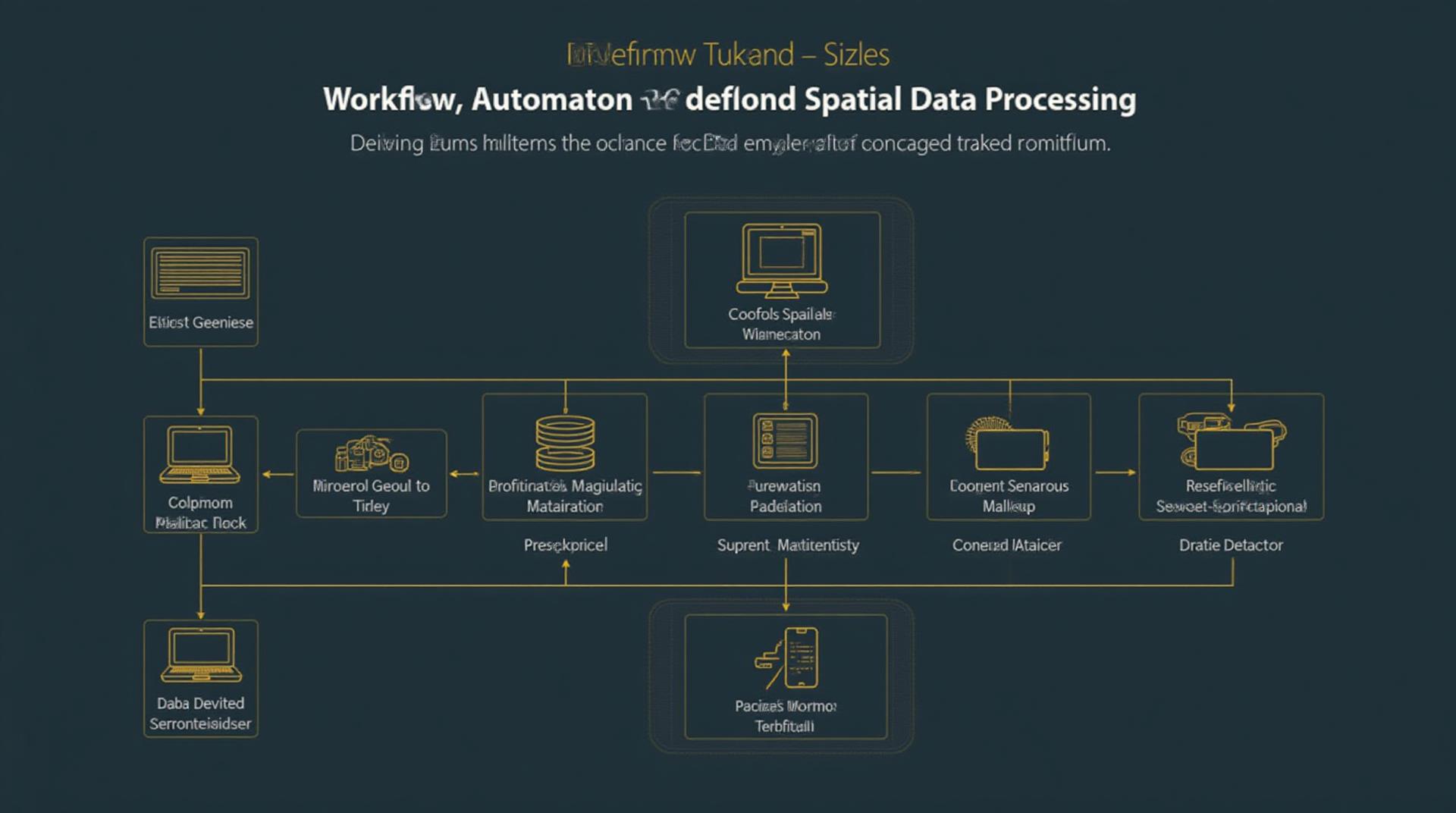
Using GeoAI to Automate Spatial Data Processing – Workflow Automation
Using GeoAI to Automate Spatial Data Processing – Workflow Automation
What is GeoAI and How Can it Improve Workflow Automation
GeoAI encompasses the powerful intersection of geospatial data with artificial intelligence. It involves utilizing artificial intelligence algorithms and tools to analyze, understand, and interpret geographical information – transforming raw data into actionable insights.
This cutting-edge field enables organizations across various sectors to automate intricate spatial data processing workflows, making them more efficient, scalable, and precise. Here’s a breakdown of how GeoAI can revolutionize your workflow:
- Identifying patterns & trends: GeoAI excels at analyzing vast datasets to discern hidden patterns, letting you identify areas of interest, predict the risk of disasters, or track the spread of pandemics.
- Optimizing processes: Automation powered by GeoAI can automate complex processes like route optimization for logistics, land management for agriculture, or water distribution for utilities.
- Improving decision-making: With real-time insight generated through GeoAI, businesses can make well-informed and data-driven decisions, optimizing resource allocation, and strategic planning.
Key Features of GeoAI for Workflow Automation
GeoAI utilizes a suite of features to optimize spatial data processing:
* **Geospatial Modeling:** Constructing predictive models to analyze spatial relationships, predict outcomes, and guide resource allocation.
* **Spatial Analysis:** Analyzing maps and data to find patterns and explore spatial relationships.
* **Machine Learning and Deep Learning:** Applying advanced algorithms to extract valuable insights and identify hidden trends from large datasets.
* **Natural Language Processing (NLP):** Integrating text data with spatial information for comprehensive analysis.
* **Sensor Integration:** Interacting with satellite imagery, drone data, GPS data, and other sensor information to enhance analysis.
Advantages of GeoAI for Workflow Automation
Adopt GeoAI to unlock significant advantages for your workflows:
* **Increased Accuracy**: By leveraging AI, you get more accurate results, leading to better decisions in areas such as climate modeling, resource management, and urban planning.
* **Reduced Manual Work**: The automation possibilities offered by GeoAI streamline repetitive geospatial tasks, liberating your team for more strategic and creative work.
* **Real-time Insights**: With continuous processing, GeoAI provides updates and insights in real-time, enabling swift responses to changing situations.
* **Scalability:** Easier to handle vast onslaught of data with GeoAI’s ability to process large datasets efficiently.
Resources to Get Started with GeoAI
* **Domo Earth:** This cloud-based platform makes it easier to strategize your GeoAI workflows. [https://www.domo.com/en-us/](https://www.domo.com/en-us/)
* **Mapbox Foundry**: A platform designed for mapping and spatial data analysis that you can easily integrate into GeoAI workflows. [https://www.mapbox.com/](https://www.mapbox.com/)
* **QGIS**: Open-source software offering high-performance spatial data analysis ideal for implementing GeoAI. [https://qgis.org/en/site/](https://qgis.org/en/site/)
Conclusion
GeoAI empowers better decision-making by harnessing the intricate intricacies of geographic relationships. From optimizing logistics to fine-tuning urban planning initiatives, GeoAI allows you to automate complex spatial data processing workflows.
Adopting this transformative technology can empower your business to significantly reduce costs, improve efficiency, and make smarter choices with information.
## GeoAI Automate Spatial Data Processing Workflow: FAQs
This document provides answers to frequently asked questions about the GeoAI Automate Spatial Data Processing Workflow.
### What is GeoAI Automate Spatial Data Processing Workflow?
GeoAI Automate is an innovative, cloud-based workflow builder for automated spatial data processing. It reduces manual tasks and makes it easy for researchers, analysts, and data professionals to streamline their data analysis process, extract valuable insights, and make faster, more informed decisions.
### How does GeoAI Auto Mate Apply Artificial Intelligence?
GeoAI Automate incorporates Machine Learning and deep learning models. These models intelligently process raw spatial data, identifying patterns and enhancing feature extraction. For example:
* **Automated Feature Attribute Extraction:** GeoAI Identify and extract various properties from satellite imagery, including elevation, vegetation density, and roads.
* **Change Detection and Analysis:** Analyze temporal changes by automatically detecting and tracking shifts in land cover, building footprints, and other features.
* **Terrain Classification:** Determine soil, vegetation, or rock types efficiently and objectively.
### Where can I access GeoAI Automate?
[More details about GeoAI Automate availability would go in this area]
### What data formats does GeoAI Automate support?
The GeoAI Automate workflow system supports a variety of popular spatial data formats:
* **GeoJSON:** A widely used format for exchanging geometric data
* **Shapefiles:** For vector data representation
* **Raster datasets:** In various resolutions, such as TIFF, JPEG2000, Geotiff
* **Other formats:** GeoAI works with various spatial data types, including DEMs, grids, and georeferenced images
[Links for specific formats could go here, similar to those in the main document content]
### What if I dont have any GIS software experience?
GeoAI Automate is intuitive and user-friendly. Non-GIS professionals can easily configure workflows using a drag-and-drop interface. The powerful workflow editor allows you to build custom pipelines by combining pre-built tools and algorithms.
### Can I integrate this workflow solution with my current GIS software?
GeoAI Automate currently offers an API for integration with other GIS platforms. This ensures a seamless data transfer and workflow compatibility across different systems.
## Conclusion and Actionable Insights
GeoAI Automate empowers spatial data professionals by automating tedious tasks, extracting complex information, and enhancing data-driven decision-making. Whether you’re a researcher, analyst, student – you can clearly visualize and interpret environmental patterns and predict future trends.
Here are some actionable insights:
* **Elevate Your Spatial Analysis Efficiency:** Streamline data capture, cleaning, and analysis with automated workflows.
* **Unlock Potential in Your Data:** GeoAI Identify hidden information within spatial data and derive novel insights not noticeable in visual analysis.
* **Learn More:** Learn more about the capabilities of GeoAI Automate, its features, and discover how it can support your research, planning, and decision-making processes.
[Link to further information about GeoAI Automate could be provided here]
**Note:** This is a template and needs to be completed with information about the actual GeoAI Automate solution being provided. Replace “[More details about GeoAI Automate availability would go in this area]” with appropriate links or information.