
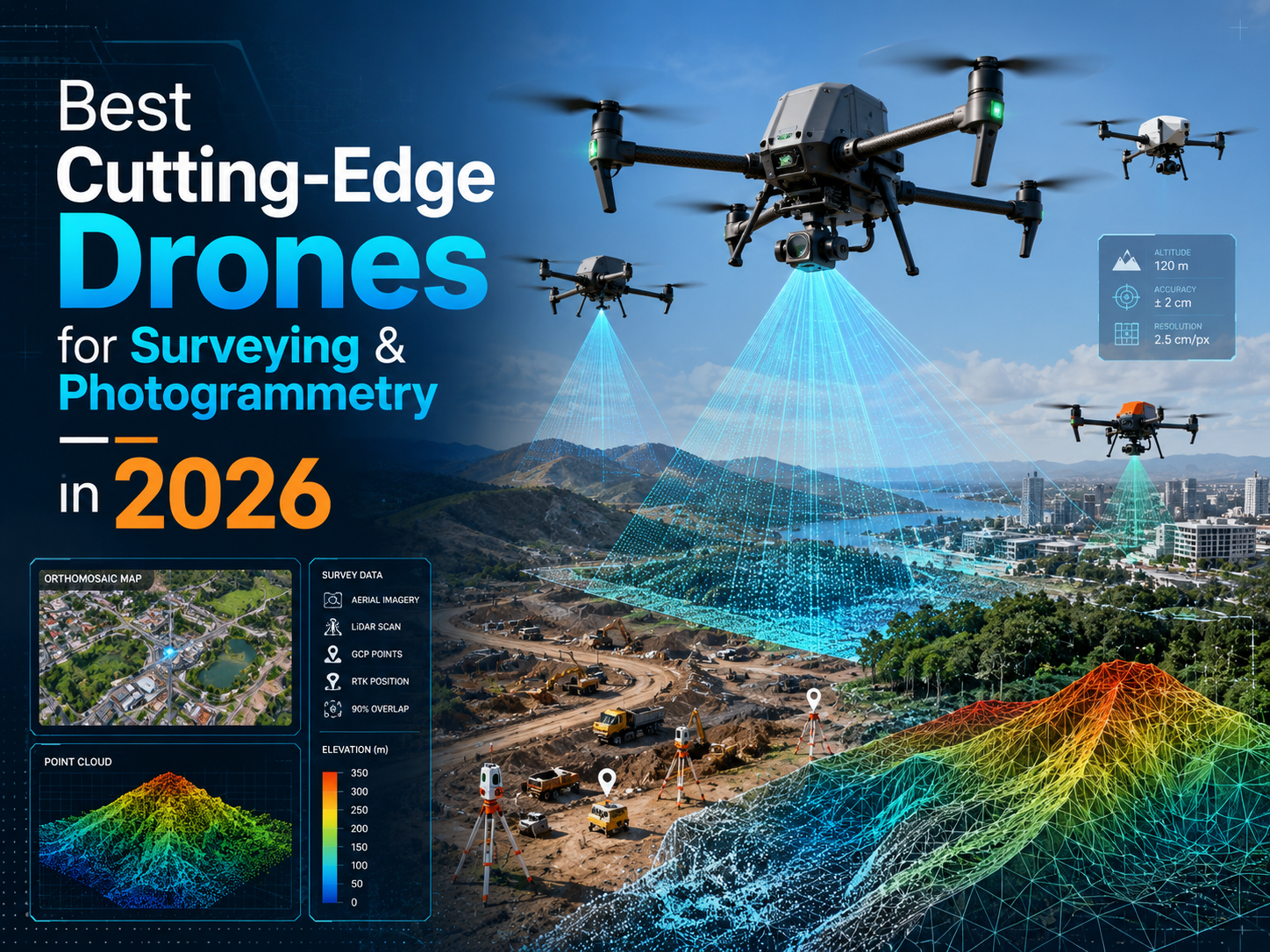
Best Cutting-Edge Drones for Surveying & Photogrammetry in 2026
Table of Contents
- DJI Matrice 400 with Zenmuse P1 and Zenmuse L2
- DJI Matrice 4E
- WingtraOne GEN II
- Quantum Systems Trinity Pro
- Freefly Astro / Astro Max with Sony LR1 Mapping Payload
- Inspired Flight IF800
- AgEagle eBee X / eBee TAC
- Skydio X10
- What is the best drone for surveying in 2026?
- Is RTK or PPK better for drone mapping?
- Do I still need ground control points?
- Are fixed-wing drones better than multirotors for photogrammetry?
- What camera specs matter most for photogrammetry?
- Can one drone handle both photogrammetry and LiDAR?
- How accurate are surveying drones?
Drone surveying has moved from a specialist add-on to a core geospatial workflow. In 2026, the best drones for surveying photogrammetry 2026 are not simply the drones with the longest flight time or the highest camera resolution. The strongest platforms combine RTK or PPK positioning, reliable flight planning, high-quality sensors, repeatable workflows, and compatibility with professional mapping software.
For land surveyors, GIS teams, engineers, construction firms, mining operators, and environmental mapping teams, the right drone can reduce field time, improve safety, and deliver high-resolution outputs such as orthomosaics, 3D models, DEMs, DSMs, stockpile volumes, contours, point clouds, and inspection-ready imagery. The wrong drone, however, can create accuracy problems, slow processing, or produce data that is not defensible for paid survey work.
Software
This guide compares the leading surveying drones, photogrammetry drones, mapping drones, RTK drone platforms, PPK drone systems, and LiDAR-ready aircraft worth considering in 2026.
What Makes a Drone Good for Surveying and Photogrammetry?
A professional surveying drone should be evaluated as a full data-capture system, not just as an aircraft. The most important factors are positioning, camera quality, flight efficiency, payload options, processing workflow, and support.
RTK and PPK GNSS are essential for high-accuracy drone mapping. RTK corrects positioning during flight, while PPK applies corrections after the flight. Pix4D notes that centimeter-grade mapping workflows generally require RTK/PPK image geolocation, ground control points, or both, and recommends checkpoints to assess final model accuracy. (Pix4D Support)
Camera quality is equally important. For photogrammetry, a mechanical or global mechanical shutter is usually preferred because it reduces motion distortion during image capture. DJI’s Zenmuse P1, for example, uses a 45 MP full-frame sensor with a mechanical shutter, while the DJI Matrice 4E includes a 20 MP 4/3 wide camera with mechanical shutter capability. (DJI Official)
Flight time and coverage matter, but they must be read carefully. Manufacturer flight times are typically measured in ideal conditions. Payload, wind, altitude, overlap, terrain-following, and return-to-home reserve can reduce real-world mission time. Fixed-wing and VTOL drones usually cover large sites more efficiently than multirotors, while multirotors are better for vertical assets, confined sites, construction monitoring, and LiDAR payload flexibility.
Accuracy must be verified, not assumed. ASPRS positional accuracy standards provide industry guidance for digital geospatial data, including photogrammetry, LiDAR, UAS, and field surveying workflows. (ASPRS) For paid survey work, use independent checkpoints even when flying RTK or PPK.
Best Seller in Amazon for Photogrammetry


Best Drones for Surveying Photogrammetry 2026: Quick Comparison
| Drone/platform | Best for | Airframe type | Camera/payload options | RTK/PPK support | Claimed flight time | Key strengths | Limitations | Ideal user |
|---|---|---|---|---|---|---|---|---|
| DJI Matrice 400 + Zenmuse P1/L2 | Heavy-duty survey, LiDAR, enterprise mapping | Multirotor | Zenmuse P1, Zenmuse L2, other DJI/third-party payloads | RTK | Up to 59 min | 6 kg payload, strong sensor ecosystem, LiDAR-ready | Large, expensive, quote-based | Enterprise survey teams |
| DJI Matrice 4E | Compact RTK photogrammetry | Multirotor | Built-in 20 MP 4/3 mechanical-shutter wide camera, tele cameras | RTK | Up to 49 min | Portable, mapping-focused, fast deployment | Less payload flexibility than Matrice 400 | Construction, mining, small survey teams |
| WingtraOne GEN II | High-accuracy large-area mapping | VTOL fixed-wing | RGB61, Sony, multispectral, oblique options | PPK option | Up to 59 min | VTOL landing, large coverage, survey workflow | Less flexible for inspection/LiDAR than multirotors | Surveyors mapping large sites |
| Quantum Systems Trinity Pro | Large-area corridor and land mapping | eVTOL fixed-wing | RGB, oblique, multispectral, LiDAR | PPK/mission-integrated workflows | 90+ min | Up to 700 ha or 100 km corridor coverage | Higher training/procurement complexity | Utilities, mines, corridors, cadastre |
| Freefly Astro / Astro Max + LR1 | NDAA-conscious high-res mapping | Multirotor | Sony ILX-LR1 61 MP mapping payload, LiDAR options | RTK/PPK workflows | Typical LR1 mission 25–29 min | 61 MP full-frame payload, US ecosystem | Shorter mapping endurance than fixed-wing | US-based mapping and inspection teams |
| Inspired Flight IF800 | NDAA/Blue UAS LiDAR-ready work | Multirotor | Photogrammetry, multispectral, LiDAR payloads | RTK/PPK module support | Up to 54 min | US-made, modular payload rail, hot-swappable batteries | Payload integration may require planning | Government, utilities, LiDAR teams |
| AgEagle eBee X / eBee TAC | Lightweight fixed-wing mapping | Fixed-wing | S.O.D.A., Aeria, multispectral options | RTK/PPK available | Up to 90 min | Very efficient large-area mapping | Needs landing space, less hovering flexibility | Agriculture, GIS, cadastral mapping |
| Skydio X10 | Autonomous compact mapping and inspection | Multirotor | 50 MP wide, 64 MP narrow, thermal options | RTK mapping workflows | Up to 40 min | Autonomy, obstacle avoidance, compact deployment | Electronic shutter; not a traditional survey camera | Industrial sites, complex environments |
Individual Drone Reviews
DJI Matrice 400 with Zenmuse P1 and Zenmuse L2

The DJI Matrice 400 is one of the most capable enterprise drone platforms for surveying in 2026. DJI lists a maximum payload of 6 kg and up to 59 minutes of flight time under specified test conditions. (DJI) For photogrammetry, the Zenmuse P1 remains a strong match because it combines a 45 MP full-frame sensor, interchangeable lenses, and mechanical shutter capture. (DJI Official)
For LiDAR mapping, the Zenmuse L2 integrates frame LiDAR, a high-accuracy IMU, and a 4/3 CMOS RGB mapping camera. DJI states vertical accuracy of 4 cm and horizontal accuracy of 5 cm under its listed test conditions. (DJI)
Best use cases: infrastructure corridors, mines, high-accuracy photogrammetry, LiDAR mapping, complex terrain, and repeat enterprise workflows.
Pros: strong payload ecosystem, RTK positioning, LiDAR support, high payload capacity, mature software integration.
Cons: high cost, larger logistics footprint, and more complex operations than compact drones.
Who should buy it: enterprise survey teams that need one platform for photogrammetry, LiDAR, inspection, and repeatable professional mapping.
Who should avoid it: small teams doing mostly simple site maps where a compact RTK drone is enough.
DJI Matrice 4E

The DJI Matrice 4E is designed specifically for geospatial applications such as surveying, mapping, construction, and mining. DJI lists up to 49 minutes of flight time with standard propellers, and the Matrice 4E includes a 20 MP 4/3 wide-angle camera with a mechanical shutter, plus telephoto cameras for inspection and context imagery. (DJI)
Best use cases: construction sites, quarries, stockpiles, small-to-medium topographic surveys, and rapid GIS data collection.
Software
Pros: compact, mapping-focused, RTK capable, strong camera package, faster field deployment than heavy-lift systems.
Cons: limited payload flexibility compared with Matrice 400 or open payload aircraft.
Who should buy it: surveyors and construction teams that want a professional RTK drone without carrying a heavy enterprise platform.
Who should avoid it: teams needing interchangeable LiDAR, multispectral, or third-party payload flexibility.
WingtraOne GEN II

WingtraOne GEN II is a VTOL fixed-wing mapping drone built for high-quality survey data over larger sites. It takes off and lands vertically, then flies like a fixed-wing aircraft for efficient coverage. Wingtra lists up to 59 minutes of maximum flight time, 16 m/s flight speed, IP54 rating, and a PPK option that removes the requirement for GCPs, while still recommending three checkpoints for accuracy verification. (Wingtra)
Best use cases: mining, agriculture, cadastral surveys, land management, and large construction corridors.
Pros: efficient coverage, safer VTOL landing than belly-landing fixed wings, strong mapping workflow, high-resolution camera options.
Cons: less suitable for close inspection, hovering work, or carrying heavier LiDAR payloads.
Who should buy it: teams whose main job is high-accuracy aerial surveying over large open areas.
Who should avoid it: teams that need one drone for mapping, inspection, and payload experimentation.
Quantum Systems Trinity Pro

Trinity Pro is a professional eVTOL fixed-wing platform aimed at large-area mapping and corridor work. Quantum Systems lists 90+ minutes of flight time, coverage of up to 700 ha, and corridor coverage of up to 100 km. It also supports quick-swap sensors including RGB, oblique, multispectral, and LiDAR options. (Quantum Systems)
Best use cases: utilities, pipelines, rail corridors, mining, forestry, agriculture, and cadastral mapping.
Pros: outstanding endurance, broad sensor ecosystem, efficient corridor mapping, strong mission planning.
Cons: more specialized than a multirotor and usually better suited to trained geospatial teams.
Who should buy it: organizations mapping very large areas or long linear assets.
Who should avoid it: small teams focused on compact urban sites or vertical inspection.
Freefly Astro / Astro Max with Sony LR1 Mapping Payload
Freefly Astro is a US-made commercial drone ecosystem that becomes a strong mapping option when paired with the LR1 payload. Freefly’s LR1 payload uses the Sony ILX-LR1 camera, provides 61 MP resolution, weighs 970 g with the default lens, and is listed as NDAA compliant. (docs.freeflysystems.com) Sony describes the ILX-LR1 as a 61 MP full-frame industrial camera designed for applications including UAV surveying, mapping, and photogrammetry. (Sony Pro)
Freefly’s documentation says a single Astro flight with the LR1 payload is typically 25–29 minutes, depending on mission geometry, speed, wind, and other factors. (docs.freeflysystems.com)
Best use cases: high-resolution photogrammetry, inspection-mapping hybrid workflows, US procurement-sensitive projects, and payload experimentation.
Pros: 61 MP full-frame imagery, NDAA-conscious payload, modular ecosystem, strong imaging quality.
Cons: shorter mapping endurance than fixed-wing platforms and careful battery planning is required.
Who should buy it: US-based teams needing high-resolution mapping from a modular multirotor.
Who should avoid it: teams whose main priority is maximum acreage per battery.
Inspired Flight IF800
The Inspired Flight IF800 Tomcat is a US-made medium-lift quadcopter for professional mapping, inspection, and LiDAR work. Inspired Flight lists a maximum flight time of 54 minutes, a 1.5 kg standard payload capacity, a 3 kg max payload, hot-swappable batteries, and NDAA compliance. (docs.inspiredflight.com) The aircraft also includes mounting support for GNSS antennas and RTK/PPK modules, plus payload rails for sensors, optics, and LiDAR. (Inspired Flight Technologies)
Best use cases: LiDAR mapping, utility inspection, infrastructure, public-sector work, and US compliance-sensitive projects.
Pros: payload flexibility, hot-swappable batteries, US support, RTK/PPK-friendly mounting.
Cons: payload integrations may require more planning than closed ecosystem drones.
Who should buy it: teams needing a modular NDAA-compliant drone for LiDAR and mapping.
Who should avoid it: users wanting a simple all-in-one mapping drone with minimal configuration.
AgEagle eBee X / eBee TAC
The AgEagle eBee X is a lightweight fixed-wing mapping drone built for efficient coverage. AgEagle lists up to 90 minutes of flight time and up to 500 ha / 1,235 ac coverage at 120 m with the endurance battery and S.O.D.A. camera. RTK/PPK is available for improved reliability without ground control points. (EagleNXT) The eBee TAC follows a similar large-area mapping profile, with AgEagle listing 90 minutes of flight time and up to 500 ha coverage at 120 m. (EagleNXT)
Best use cases: agriculture, environmental mapping, cadastral surveys, GIS basemaps, and open-area mapping.
Software
Pros: efficient coverage, lightweight aircraft, proven fixed-wing mapping concept.
Cons: fixed-wing operations require more attention to launch/landing conditions than multirotors or VTOL systems.
Who should buy it: GIS and survey teams focused on broad-area mapping.
Who should avoid it: teams working in tight urban sites or needing hover-based inspection.
Skydio X10
Skydio X10 is not a traditional photogrammetry-first platform, but it deserves attention in 2026 for autonomous mapping in complex environments. Skydio lists up to 40 minutes of flight time, IP55 rating, and a camera package including a 50.3 MP wide camera, 64 MP narrow camera, 48 MP telephoto camera, and thermal option. (skydio.com) Skydio also promotes X10 for RTK-supported surveying and mapping workflows powered by a Septentrio Mosaic X5 GNSS receiver. (skydio.com)
Best use cases: industrial sites, asset inspection, construction progress, confined environments, and autonomous data capture.
Pros: excellent autonomy, obstacle avoidance, fast deployment, strong inspection capability.
Cons: electronic shutter means it should be evaluated carefully for strict photogrammetry specifications.
Who should buy it: teams that value autonomy and safe navigation in complex job sites.
Who should avoid it: surveyors who require a conventional mechanical-shutter mapping camera as their default standard.
Best Drone by Use Case
| Use case | Recommended drone |
|---|---|
| Best overall surveying drone | DJI Matrice 400 with Zenmuse P1 or L2 |
| Best compact mapping drone | DJI Matrice 4E |
| Best fixed-wing/VTOL drone | Quantum Systems Trinity Pro or WingtraOne GEN II |
| Best for large-area mapping | Trinity Pro or AgEagle eBee X |
| Best for construction sites | DJI Matrice 4E or Skydio X10 |
| Best for high-accuracy photogrammetry | DJI Matrice 400 + Zenmuse P1 or WingtraOne GEN II |
| Best for LiDAR-ready workflows | DJI Matrice 400 + Zenmuse L2 or Inspired Flight IF800 |
| Best NDAA/US-made option | Inspired Flight IF800 or Freefly Astro with LR1 |
| Best budget-conscious professional option | DJI Matrice 4E or AgEagle eBee Geo/eBee X, depending on project size |
Photogrammetry vs LiDAR in 2026
Photogrammetry is usually the better first choice for orthomosaics, stockpile measurements, construction progress, building models, roads, open terrain, and visual GIS layers. It is cost-effective and produces high-resolution color outputs.
LiDAR is better when the project requires bare-earth modeling under vegetation, powerline corridors, forest structure, complex terrain, or reliable point clouds where photo matching may struggle. DJI’s Zenmuse L2 is a good example of a modern integrated LiDAR payload because it combines LiDAR, IMU, and RGB mapping camera in one system. (DJI)
Many firms need both. A practical workflow is to use photogrammetry for frequent visual mapping and reserve LiDAR for terrain, vegetation, and corridor projects where it provides a clear technical advantage.
Buying Checklist
Before choosing a surveying drone, confirm:
- Required horizontal and vertical accuracy
- Project size and expected acreage per day
- Terrain type and vegetation cover
- RTK, PPK, GCP, and checkpoint workflow
- Photogrammetry-only vs LiDAR requirement
- Mechanical shutter or rolling shutter correction needs
- Camera resolution, sensor size, and lens options
- Flight endurance with the actual payload
- Battery count and charging workflow
- Software compatibility with Pix4D, DJI Terra, DroneDeploy, Propeller, Trimble, Esri, or your preferred stack
- Training, repair, support, and spare parts availability
- Local drone regulations, insurance, and airspace rules
Common Mistakes to Avoid
The biggest mistake is buying based only on advertised flight time. A 90-minute fixed-wing drone may be excellent for large open areas, but a compact RTK multirotor may be better for construction sites with obstacles and tight boundaries.
Another common mistake is confusing GSD with accuracy. GSD describes pixel size on the ground; it does not guarantee survey accuracy. Pix4D notes that relative accuracy depends on GSD and reconstruction quality, while absolute accuracy depends heavily on GNSS, RTK/PPK, GCPs, and checkpoints. (Pix4D Support)
Do not skip checkpoints. Even with RTK or PPK, checkpoints provide proof that the model matches known ground positions. Also avoid ignoring shutter type, overlap settings, wind, terrain-following, software costs, and battery logistics.
Final Recommendation
The best drones for surveying photogrammetry 2026 depend on the project. For enterprise teams that need maximum flexibility, the DJI Matrice 400 with Zenmuse P1 and Zenmuse L2 is the strongest all-around option. For compact professional mapping, the DJI Matrice 4E is one of the most practical choices. For large-area and corridor work, WingtraOne GEN II, Quantum Systems Trinity Pro, and AgEagle eBee X stand out. For US-made or NDAA-sensitive procurement, Freefly Astro with LR1 and Inspired Flight IF800 deserve serious consideration.
There is no single best drone for everyone. Choose based on accuracy requirements, site size, payload needs, software workflow, support, and the type of deliverables your clients expect.
Disclaimer: Drone regulations, pricing, payload compatibility, accuracy, and operating requirements vary by country, configuration, firmware, processing software, and field workflow. Always verify current specifications and local rules before purchase or flight.
FAQ
What is the best drone for surveying in 2026?
For enterprise survey teams, the DJI Matrice 400 with Zenmuse P1 or Zenmuse L2 is one of the strongest overall options. For compact mapping, the DJI Matrice 4E is easier to deploy. For large-area mapping, WingtraOne GEN II, Trinity Pro, and eBee X are better suited.
Is RTK or PPK better for drone mapping?
RTK is useful when real-time corrections are reliable. PPK is often preferred when signal reliability is uncertain because corrections are processed after flight. Both can support high-accuracy mapping when used correctly.
Do I still need ground control points?
Not always, but checkpoints are strongly recommended. GCPs can improve georeferencing, while checkpoints verify final accuracy. For survey deliverables, independent checkpoints are a best practice.
Are fixed-wing drones better than multirotors for photogrammetry?
Fixed-wing and VTOL drones are usually better for large-area mapping because they cover more ground per flight. Multirotors are better for smaller sites, vertical assets, LiDAR payloads, and complex environments.
What camera specs matter most for photogrammetry?
Sensor size, resolution, lens quality, shutter type, image sharpness, and trigger interval matter most. A mechanical shutter is often preferred for mapping because it reduces motion distortion.
Can one drone handle both photogrammetry and LiDAR?
Yes. Platforms such as DJI Matrice 400 and Inspired Flight IF800 can support both photogrammetry and LiDAR workflows, depending on payload compatibility and software.
How accurate are surveying drones?
Accuracy depends on GSD, camera quality, RTK/PPK, GCPs, checkpoints, processing software, terrain, and operator workflow. For professional work, always verify results with surveyed checkpoints rather than relying only on manufacturer claims.