geoai-contaminant-detection

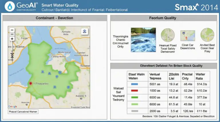
GeoAI for Smart Water Quality – Contaminant Detection

Revolutionizing Water Quality: Unveiling the Power of GeoAI In today’s world, where clean, safe water is a fundamental human right, the challenge of mitigating pollution and ensuring water quality arises at an alarming pace. Fortunately, geoAI, a captivating intersection of Geographic Information Systems and artificial intelligence, presents a powerful solution to this pressing concern. GeoAI…

geoai-data-summarization

AI in Geospatial Data Aggregation – Summarization

AI in Geospatial Data Aggregation: Summarization In the age of burgeoning big data, extracting meaningful insights from sprawling geospatial datasets has become a critical challenge. Enter artificial intelligence (AI), transforming the way we analyze and summarize large amounts of geographically linked information. What is Geospatial Data Aggregation Summarization? Geospatial data aggregation summarization involves automatically consolidating…

geoai-public-transit

GeoAI for Smart Transportation – Public Transit Optimization

# GeoAI for Smart Transportation: Public Transit Optimization Unveiling the Power of GeoAI for Public Transit Optimization Across the globe, the demand for reliable, cost-efficient, and sustainable public transport continues to surge. Emerging technologies, including Artificial Intelligence (AI) and Geographic Information Systems (GIS), hold immense potential to revolutionize public transit operations. GeoAI, the intersection of…

geoai-missing-data

AI for Geospatial Data Reconstruction – Missing Data

AI for Geospatial Data Reconstruction: Handling Missing Data Geospatial data, encompassing geographic locations and Earth observations, holds immense potential for insights into environmental changes, disaster analysis, urban planning, and numerous other areas. However, these datasets often suffer from missing data, gaps in spatial information that hinder analysis and modeling. Fortunately, Artificial Intelligence (AI) has emerged…

geoai-asset-management

GeoAI for Smart City Infrastructure – Asset Management

GeoAI for Smart City Infrastructure – Asset Management GeoAI is transforming the way urban environments are managed, and asset management stands at the forefront of this revolution. This powerful combination of geographic information systems (GIS) and artificial intelligence (AI) is revolutionizing cities by enabling smarter, more data-driven approaches to tracking, monitoring, and optimizing infrastructure assets….

geoai-data-conversion

AI in Geospatial Data Transformation – Data Conversion

Unlocking Insights from Data: The Power of AI in Geospatial Data Transformation The geospatial world is a tapestry of information, woven with data from satellites, sensors, and ground observations. However, this complex architecture of point-cloud data, imagery and location-tagged files is often fragmented and needs meticulous preparation to unlock its true value for analysis. Luckily,…

geoai-crop-disease

GeoAI for Smart Agriculture – Crop Disease Detection

GeoAI for Smart Agriculture: Crop Disease Detection The agricultural landscape is undergoing a revolution, fueled by cutting-edge technologies such as GeoAI. This transformative force is being employed to combat crop disease, preventing significant yield losses and ensuring global food security. By harnessing the power of geospatial intelligence and artificial intelligence, farmers can now make more…

geoai-enhanced-models

AI for Geospatial Data Augmentation – Enhanced Models

AI for Geospatial Data Augmentation: Enhanced Models The world relies heavily on spatial data. From mapping and navigation to climate monitoring and disaster response, understanding location is critical. Unfortunately, geospatial data is often incomplete, sparse, or inconsistent – serious issues for advanced analysis. Thankfully, the integration of artificial intelligence (AI) is revolutionizing how we handle…

geoai-flood-prediction

GeoAI for Smart Water Systems – Flood Prediction

GeoAI for Smart Water Systems – Flood Prediction: A Closer Look As our world faces increasing challenges related to resource management and climate change, innovative solutions are critical. GeoAI, the application of artificial intelligence and geographical data, offers exciting possibilities for enhancing our understanding of water systems and helping us mitigate the risks of flooding….

geoai-spatial-grouping

AI in Geospatial Data Clustering – Spatial Grouping

Unlocking Insights with AI in Geospatial Data Clustering: Spatial Grouping What is Geospatial Data Clustering and How Does AI Enhance It? Geospatial data clusters represent a powerful tool for analysis, allowing us to discern geographic patterns and trends. In simple terms, they group geographically proximate data points (often locations) based on their similarities. Think of…