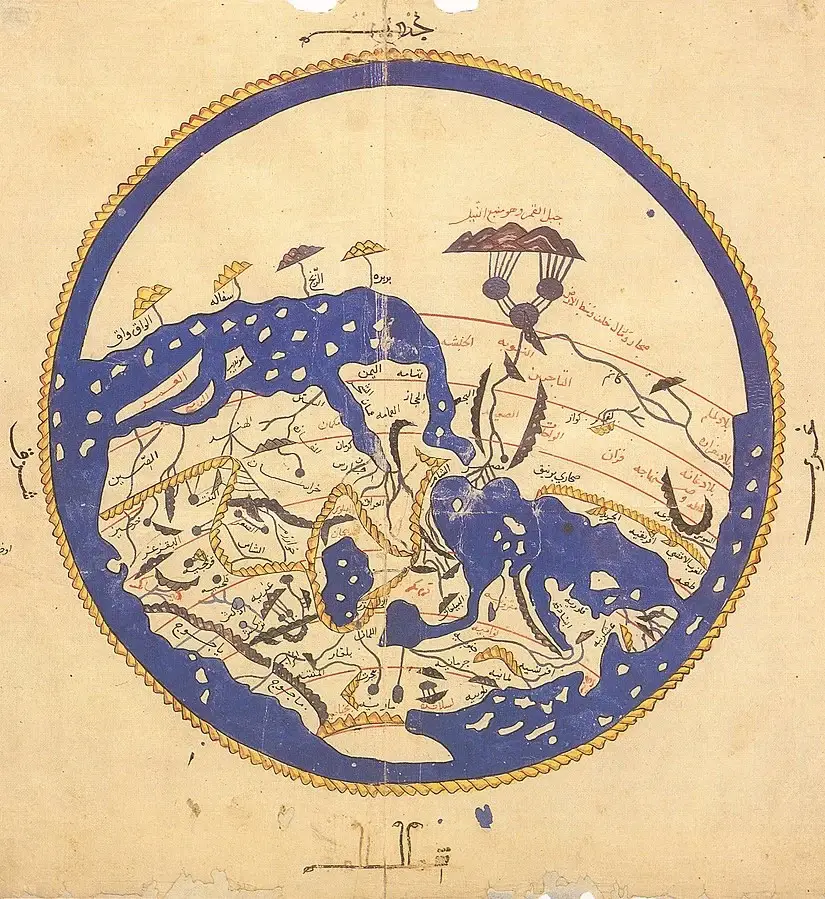
The first most accurate world map of AL-IDRISI
World map of AL IDRISI
Al-Idrisi, also known as Ash-Sharif al-Idrisi, is famous for his detailed world map. He made it for King Roger II of Sicily. The map, called “Nuzhat al-Mushtaq fi Ikhtiraq al-Afaq,” or “The Pleasure Excursion of One Who Is Eager to Traverse the Regions of the World,” is a major milestone in cartography.

This map, from the 12th century, showed the world in a new light. Al-Idrisi’s travels and research made it incredibly accurate for its time. His work paved the way for future map-making and exploration.
Key Takeaways
- Al-Idrisi’s world map is considered the first accurate representation of the world in the 12th century.
- The map, titled “Nuzhat al-Mushtaq fi Ikhtiraq al-Afaq,” was commissioned by the Norman King Roger II of Sicily.
- Al-Idrisi’s extensive travels and meticulous research enabled him to create a highly detailed and accurate map.
- The map challenged the prevailing perceptions of the world at the time and laid the foundation for future advancements in cartography.
- The map’s significance lies in its pioneering role in the development of accurate world mapping and its influence on later cartographers.
Introduction to Al-Idrisi: The Pioneering Cartographer
In the world of cartography, Al-Idrisi is a shining star. Born in the 12th century, Al-Idrisi, or Abū Abdallāh Muhammad al-Idrīsī, was a top Arab geographer and cartographer. His work changed how we see and map the world.
Al-Idrisi’s Background and Contributions
Al-Idrisi was born in Ceuta, Africa’s northern coast. He traveled and studied a lot. His detailed maps made him known as “the father of cartography.”
His travels and research gave him a lot of geographic knowledge. He put it all in his famous book, the Nuzhat al-Mushtaq fi Ikhtiraq al-Afaq. This book, made for King Roger II of Sicily, is the first accurate world map.
The Significance of Accurate World Maps
Al-Idrisi‘s work was very important. His maps were known for being accurate and detailed. They helped people understand the world better and explore new places.
His work has had a lasting impact. It helped advance geographic knowledge and exploration. Al-Idrisi is a true pioneer in cartography.
The Nuzhat al-Mushtaq fi Ikhtiraq al-Afaq
The medieval world saw a big change with the “Nuzhat al-Mushtaq fi Ikhtiraq al-Afaq.” This was made by Al-Idrisi, a famous geographer and cartographer. It was a game-changer in the 12th century, changing how people saw the world.
Overview of Al-Idrisi’s Pioneering Work
The “Nuzhat al-Mushtaq” was a standout piece. It mixed Al-Idrisi’s travels, careful notes, and new map-making ways. It showed the world’s geography, culture, economy, and politics in detail.
- The “Nuzhat al-Mushtaq” was made for Roger II, the Norman king of Sicily. He wanted the best map of the world.
- Al-Idrisi worked for nearly 20 years. He talked to travelers and wrote down his findings for this amazing work.
- The book came with world maps that were very detailed and accurate. This changed cartography forever.
The “Nuzhat al-Mushtaq” showed Al-Idrisi’s amazing skills and deep knowledge of the world. It was a key work that helped cartography and geography grow. It made the al idrissi and idrisi world more known and accurate.
“The ‘Nuzhat al-Mushtaq’ was a revolutionary work that transformed the way the medieval world perceived and understood its geography.”
Mapping Techniques and Innovations
Al-Idrisi, a famous cartographer from the 12th century, changed mapmaking with his new techniques. His world map, called the “Tabula Rogeriana,” showed his skill in combining lots of geographical information.
Al-Idrisi used trigonometry and astronomy to find exact locations on his maps. This made his maps much more accurate than anyone else’s at the time.
He also paid a lot of attention to detail and included new discoveries in his maps. Al-Idrisi got his information from travelers, traders, and scholars. This way, he could show the world in a way that was never seen before.
| Mapping Technique | Description |
|---|---|
| Trigonometry | Al-Idrisi used trigonometry to precisely determine the coordinates and positions of various geographical features, ensuring greater accuracy in his maps. |
| Astronomy | By incorporating astronomical observations, Al-Idrisi was able to enhance the precision of his maps, particularly in terms of latitude and longitude. |
| Comprehensive Data Collection | Al-Idrisi meticulously gathered information from a wide range of sources, including travelers, traders, and scholars, to create a more comprehensive and accurate representation of the world. |
Al-Idrisi’s work was a big step forward in cartography, GIS, and mapping. His dedication to detail and accuracy made his maps stand out. His work is still studied and admired today.
“Al-Idrisi’s maps were a remarkable achievement, setting new standards for precision and detail in the representation of the world.”
Accuracy and Precision in Al-Idrisi’s Maps
Al-Idrisi, a famous cartographer from the 12th century, is known for his accurate world maps. His work, the Nuzhat al-Mushtaq fi Ikhtiraq al-Afaq, showed great precision. It was far better than maps made before him.
Comparison to Earlier Maps
Al-Idrisi’s maps were much more accurate than old maps. His “Tabula Rogeriana” map showed the world more clearly and accurately than before.
Factors Contributing to Improved Accuracy
Several things made Al-Idrisi’s maps so accurate:
- He traveled a lot and saw things for himself.
- He used information from many sources, like merchants and travelers.
- He used new surveying methods, like astronomy, to make his maps better.
Utilized extensive travel data, reliable sources, and advanced surveying techniques
| Map | Accuracy | Key Innovations |
|---|---|---|
| Earlier World Maps | Limited and distorted | Relied on limited data and traditional cartographic methods |
| Al-Idrisi’s “Tabula Rogeriana” | Highly accurate and comprehensive |
Al-Idrisi’s maps were a big step forward in cartography. They set a high standard for future maps.
map world map world mappingal iDRISSI cartography gis
The world map by Al-Idrisi is a key piece in mapping history. Made in the 12th century, it was a huge leap forward. It showed the world in a way that was never seen before.
Al-Idrisi’s map, called the Tabula Rogeriana, was made for King Roger II of Sicily. It was a massive project that showed the world’s geography in great detail. This map was a true masterpiece, showing the world with unmatched precision.
The map was detailed and covered a lot of ground. It went from the Iberian Peninsula to China and from Scandinavia to Africa. It showed the world’s landforms, coastlines, and where different places were.
| Feature | Description |
|---|---|
| Scale | Comprehensive coverage of the known world at the time |
| Accuracy | Unprecedented level of precision in depicting landforms, coastlines, and regional positions |
| Innovation | Incorporation of advanced mapping techniques and data collection methods |
The Tabula Rogeriana showed Al-Idrisi’s creative side in cartography. He used new mapping methods and included important trade and cultural info. This made his map stand out and set the stage for future cartographers.
Al-Idrisi’s map was a big step forward in mapping. It helped people understand the world better. It was a key tool for explorers and scholars, showing them the world in a new light.
Influence on Later Cartographers
Al-Idrisi, a famous 12th-century cartographer, changed the world of cartography and mapping forever. His world map, called the “Nuzhat al-Mushtaq fi Ikhtiraq al-Afaq,” raised the bar for accuracy and detail. This map inspired many cartographers who came after him.
Impact on European and Arab Cartography
Al-Idrisi’s work inspired both European and Arab cartographers. His deep understanding of geography and his focus on detail changed how maps were made. This led to more accurate and detailed world maps.
European cartographers like Abraham Cresques were influenced by Al-Idrisi. They used his methods to improve their maps. Arab cartographers also built on Al-Idrisi’s work, enhancing their understanding of the world.
“Al-Idrisi’s world map was a game-changer in the field of cartography, setting a new standard for accuracy and precision that would influence generations of mappers to come.”
The impact of Al-Idrisi on mapping is huge. His work is still studied and admired today. It shows how innovation and a love for geography can change the world.
Cultural and Historical Significance
The world map by Al-Idrisi is very important. It was made in the 12th century by a famous Arab geographer. This map shows what people thought and knew back then.
Al-Idrisi’s map, called the “Tabula Rogeriana,” was made for King Roger II of Sicily. It’s one of the most detailed maps from the Middle Ages. Its accuracy and detail have helped historians understand the past.
The Tabula Rogeriana also shows the diversity of the medieval world. It combines information from Arabs, Persians, and Europeans. This mix shows how different cultures worked together during that time.
As Al-Idrisi himself stated, “The world is a garden, and the wise are those who can walk its paths.”
Al-Idrisi’s map is more than just a map. It shows the achievements of the medieval Islamic world. It helped spread knowledge and shape how people saw the world.
Today, the Tabula Rogeriana is still important for scholars. It gives us a peek into the medieval world’s politics, economy, and culture. It reminds us of the value of studying different cultures and their achievements.
Modern Applications of Al-Idrisi’s Work
Al-Idrisi’s cartographic work still influences modern GIS and digital mapping today. His detailed world map and innovative methods have shaped many GIS principles. These principles are key in today’s digital mapping tools.
Relevance in Geographic Information Systems (GIS)
Al-Idrisi’s world map and detailed descriptions are crucial for GIS development. His focus on accuracy and diverse data sources has shaped today’s digital mapping tools.
The GIS field uses many of Al-Idrisi’s ideas. These include latitude and longitude, multiple data layers, and spatial relationships. These elements help create detailed, interactive maps for precise geographic analysis.
| Al-Idrisi’s Contributions | Modern GIS Applications |
|---|---|
| Comprehensive world map with detailed geographical features | Digital mapping and spatial data integration |
| Emphasis on accuracy, scale, and diverse data sources | Precise data capture, analysis, and visualization |
| Use of latitude and longitude coordinates | Georeferencing and spatial analysis |
| Representation of spatial relationships | Modeling and understanding of geographic phenomena |
Al-Idrisi’s work continues to influence GIS and digital mapping. It helps researchers, planners, and decision-makers understand our world better.
Challenges and Limitations
Al-Idrisi’s world map was a big step forward in cartography. Yet, it faced many challenges and had its limits. The map’s accuracy was limited by the data, technology, and science of the time.
Factors Affecting Map Accuracy
The 12th century had limited geographic information and exploration data. Many parts of the world were still unknown. Travelers’ measurements and observations were often not precise or consistent.
This led to some features and locations being wrong or missing on the map. The methods for measuring distances and mapping coastlines were not as advanced as today. Al-Idrisi used traditional methods like pacing and estimating travel times, which could have errors.
He also lacked modern navigational tools and surveying equipment. This made it hard to get the map’s spatial relationships and scale right.
Also, political and cultural biases of the era might have shaped the map. Al-Idrisi worked for the Sicilian king, Roger II. The map might show the interests and views of the ruling elite at that time.
FAQ
What was the significance of Al-Idrisi’s world map?
Al-Idrisi’s world map, made in the 12th century, was a major breakthrough. It was one of the first maps to show the world accurately. It greatly influenced cartography and our understanding of the world during the Middle Ages.
Who was Al-Idrisi, and what were his contributions to cartography?
Al-Idrisi was a famous Arab geographer and cartographer from the 12th century. He is known for his groundbreaking work in cartography. His “Nuzhat al-Mushtaq fi Ikhtiraq al-Afaq” atlas included one of the most accurate maps of its time.
What were the key innovations and techniques used by Al-Idrisi in creating his world map?
Al-Idrisi used advanced mapping techniques and new geographical knowledge to make his map more accurate. He relied on better data sources, advanced surveying, and a deeper understanding of the world.
How did Al-Idrisi’s world map compare to earlier cartographic efforts?
Al-Idrisi’s map was a big step forward in map accuracy. It was more detailed and accurate than earlier maps. This was due to the increased knowledge and surveying techniques of the time.
What factors contributed to the improved accuracy of Al-Idrisi’s world map?
Several factors made Al-Idrisi’s map more accurate. Better data sources, advanced surveying, and a broader understanding of the world helped. His focus on detail and combining geographic and historical information also improved the map’s precision.
How did Al-Idrisi’s work influence later cartographers and the development of cartography?
Al-Idrisi’s map had a big impact on cartography in both Europe and the Arab world. His work inspired later cartographers. They used his techniques and added new knowledge to create even more accurate maps.
What is the cultural and historical significance of Al-Idrisi’s world map?
Al-Idrisi’s map shows the knowledge and views of the medieval period. It gives insights into the geographic understanding and worldviews of the time. It was shaped by the politics, society, and knowledge of the era.
How are Al-Idrisi’s cartographic principles and techniques still relevant in the modern era of geographic information systems (GIS)?
Al-Idrisi’s work still influences modern GIS and digital mapping. His focus on detail, use of reliable data, and combining geographic information are key in digital cartography and spatial analysis.
What were some of the challenges and limitations associated with Al-Idrisi’s world map?
Al-Idrisi’s map was a big step forward, but it had its challenges. Limited knowledge, technological limits, and reliance on secondary sources could have affected its precision.


One Comment