Cutting Edge Ground Penetrating Radar GPR 2025
Have you ever wondered what lies beneath your feet? Whether you’re a construction foreman preparing a job site, an archaeologist uncovering ancient ruins, or a curious hobbyist searching for buried treasure, one question always lingers: What’s down there? For decades, answering that question meant digging blindly—risking damage, delays, and even danger. But today, thanks to Ground Penetrating Radar (GPR), we can “see” underground without breaking a sweat—or a shovel.
Imagine this: A construction crew in downtown Chicago is about to lay a new foundation. Before they begin, they roll a small cart-like device across the pavement. Seconds later, their tablet shows a detailed cross-section of the ground below—revealing a forgotten water line, a cluster of electrical conduits, and even an old sewer pipe from the 1800s. Thanks to GPR technology, they avoid a costly and potentially dangerous excavation mistake. This isn’t science fiction—it’s real-world underground detection in action.
In this comprehensive guide, we’ll explore everything you need to know about Ground Penetrating Radar—from how it works and where it’s used, to how to choose the best ground penetrating radar for your needs. Whether you’re a professional in construction, archaeology, or utility location—or just fascinated by how technology reveals the hidden world beneath our feet—this guide will equip you with practical knowledge and expert insights.
Let’s dig in—figuratively, of course.
What is Ground Penetrating Radar?
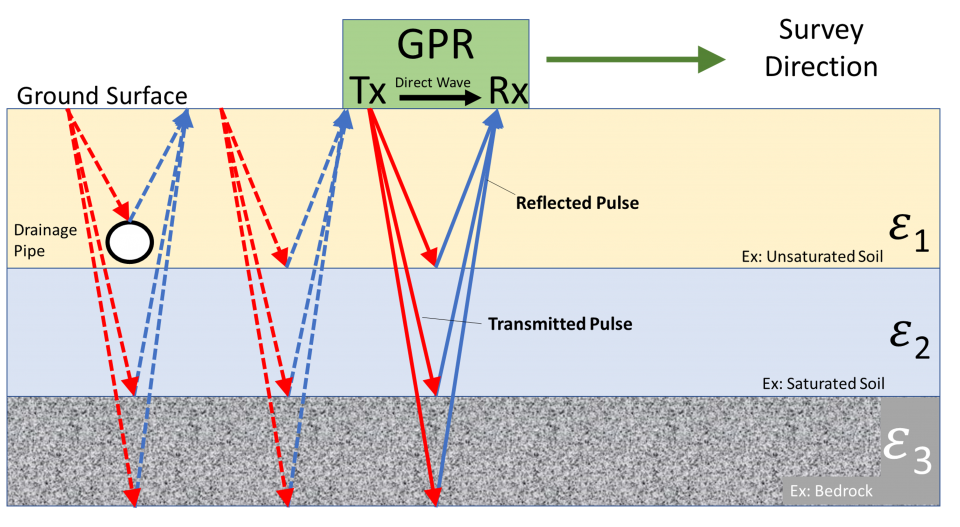
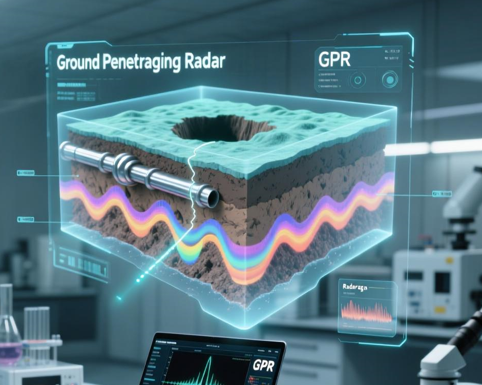
At its core, Ground Penetrating Radar (GPR) is a non-invasive imaging technology that uses high-frequency radio waves to detect objects, changes in material, and voids buried beneath the surface. Think of it as an “X-ray for the ground”—but instead of radiation, it uses electromagnetic energy to create real-time images of what’s hidden below.
The concept isn’t entirely new. GPR technology traces its roots back to the early 20th century, with rudimentary radar systems developed in the 1920s to measure ice thickness. But it wasn’t until the 1970s and 1980s that GPR became practical for widespread use, especially in military, geological, and civil engineering applications.
So how does it work? A GPR unit sends a pulse of electromagnetic energy into the ground. When that pulse hits an object or a boundary between different materials (like soil and concrete, or dirt and a metal pipe), part of the signal reflects back to the surface. A receiver in the GPR device picks up these reflections, and software translates them into visual data—usually a cross-sectional image called a radargram.
Unlike metal detectors, which only find conductive materials, GPR can detect a wide range of substances, including plastic pipes, concrete structures, voids, and even organic remains. This makes it an indispensable tool across industries—from GPR for construction to GPR for archaeology.
And the best part? It’s completely safe. GPR emits low-power radio waves, poses no health risks, and leaves no damage to the surface it scans. That’s why it’s used on historic sites, city sidewalks, airport runways, and even inside buildings.
How GPR Works – Technical Deep Dive
While the basic idea of GPR is simple, the science behind it is fascinating. Let’s take a step-by-step look at how Ground Penetrating Radar transforms invisible underground features into actionable data.
1. Transmission of Electromagnetic Waves
The GPR unit contains a transmitter antenna that sends short pulses of high-frequency radio waves (typically between 10 MHz and 2.6 GHz) into the ground. These waves travel downward at the speed of light—though their actual speed depends on the material they pass through.
2. Reflection and Refraction
When the radar wave encounters a change in material—say, from soil to a PVC pipe or concrete to air—part of the energy reflects back toward the surface. The strength and timing of this reflection depend on the dielectric permittivity of the materials involved. Materials with high contrast in permittivity (like metal in dry sand) produce strong reflections.
The rest of the wave continues deeper, potentially reflecting off multiple layers or objects.
3. Reception and Data Capture
A receiver antenna on the GPR unit captures the returning signals. The device records the two-way travel time (how long it took the wave to go down and bounce back) and the amplitude (strength) of each reflection.
4. Signal Processing and Visualization
Raw GPR data looks like a series of wavy lines. But using specialized software, this data is processed into a radargram—a 2D or 3D image that shows depth, size, and shape of subsurface features. Skilled operators can interpret these images to identify pipes, rebar, cavities, or even buried artifacts.
Factors Affecting GPR Performance
Not all ground is created equal. Several factors influence how well GPR works:
- Soil Type: Dry, sandy, or rocky soils are ideal for GPR because they allow radar waves to penetrate deeply. In contrast, clay-rich or saline soils absorb radar energy, reducing depth and clarity.
- Moisture Content: Water increases electrical conductivity, which can dampen signals. Wet soil = shallower penetration.
- Antenna Frequency: Higher frequencies (e.g., 1.5 GHz) offer better resolution but less depth. Lower frequencies (e.g., 100 MHz) penetrate deeper but with less detail.
- Target Size and Material: Large, metallic objects are easier to detect than small, non-conductive ones like plastic pipes.
Understanding these variables is crucial for getting accurate results—especially when using GPR for critical applications like utility detection or structural assessment.
Applications of Ground Penetrating Radar
One of the most impressive things about GPR technology is its versatility. From city streets to ancient ruins, GPR is quietly revolutionizing how we explore and interact with the subsurface. Let’s explore its top applications.
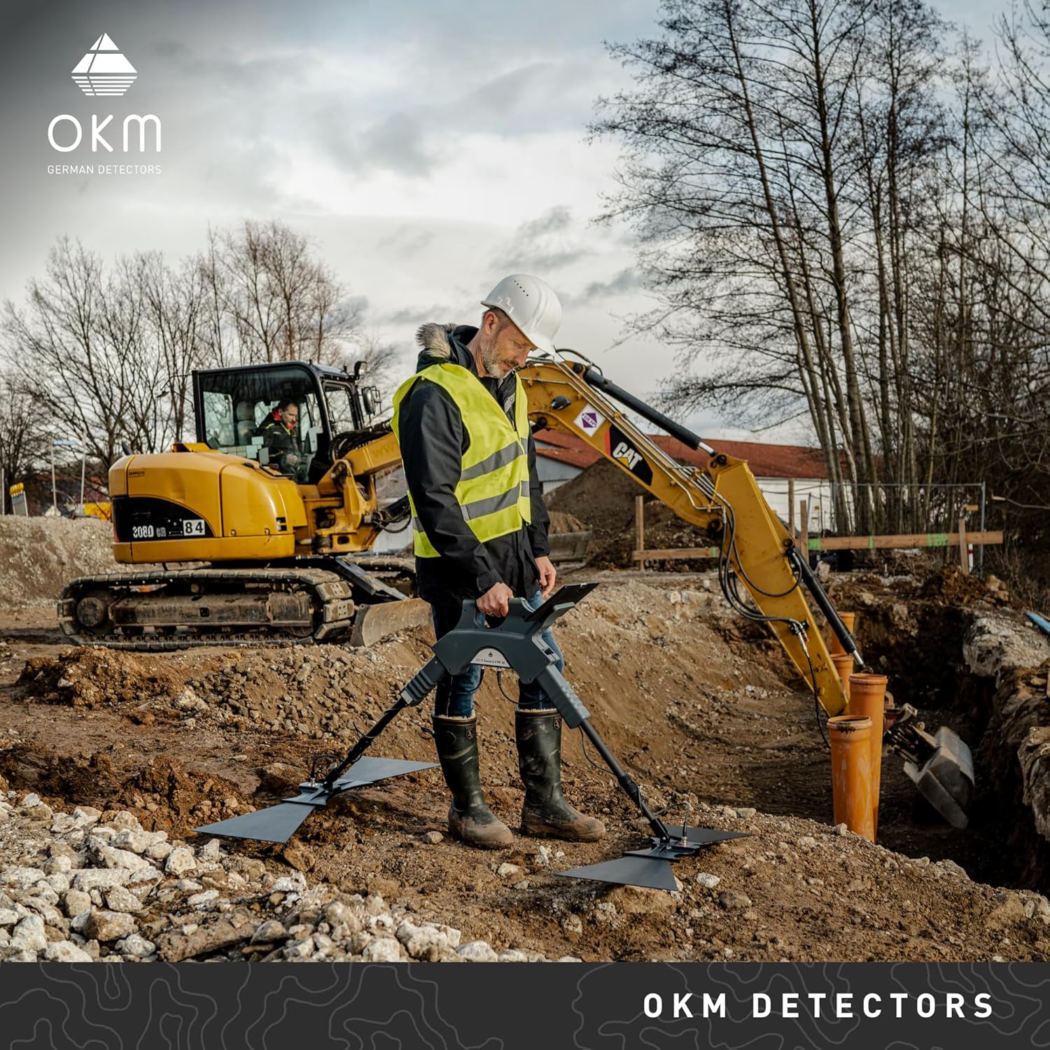
1. Utility Detection (Pipe Locator & Cable Mapping)
One of the most common and vital uses of GPR is locating underground utilities. Before any excavation, contractors must know where gas lines, water mains, fiber optics, and electrical conduits are buried.
Traditional methods like “call before you dig” (811 in the U.S.) rely on utility maps that are often outdated or incomplete. GPR fills the gap by providing real-time, on-site detection.
Example: A road crew in Texas used GPR to scan a stretch of highway before installing new streetlights. The scan revealed an unmarked gas line just 18 inches below the surface—preventing a potential disaster.
GPR excels at detecting non-metallic pipes (like PVC or concrete), which metal detectors miss. This makes it a true pipe locator powerhouse.
2. GPR for Construction & Concrete Inspection
In construction, GPR is a game-changer for concrete scanning. It can detect:
- Rebar and post-tension cables
- Voids or delamination
- Embedded conduits
- Slab thickness
This is essential before cutting, coring, or drilling into concrete floors, walls, or bridges.
Real-World Use: A renovation team in Denver used GPR to map rebar in a 40-year-old parking garage. By avoiding critical structural elements, they saved over $50,000 in potential repair costs and prevented safety hazards.
GPR is also used for as-built verification, helping engineers confirm that construction matches design plans.
3. GPR for Archaeology & Historical Preservation
Archaeologists love GPR because it allows them to explore sites without disturbing them. Instead of digging blindly, researchers can scan large areas and pinpoint promising dig locations.
Notable Example: In 2015, GPR helped discover a previously unknown structure beneath the famous Stonehenge site in England. The non-invasive scan revealed buried stones and pits, reshaping theories about the monument’s layout.
GPR is also used to:
- Map ancient foundations and walls
- Locate unmarked graves
- Investigate shipwrecks buried under sediment
Because it preserves the integrity of historical sites, GPR for archaeology is considered a gold standard in cultural resource management.
4. Geology & Environmental Studies
Geologists use GPR to study:
- Soil stratification
- Bedrock depth
- Groundwater tables
- Ice thickness (in polar regions)
Environmental scientists employ GPR to:
- Locate underground storage tanks (USTs)
- Map landfill boundaries
- Detect contaminant plumes
Its ability to provide high-resolution subsurface profiles makes it invaluable for environmental assessments and remediation planning.
5. Forensics & Law Enforcement
In criminal investigations, time is critical. GPR helps forensic teams locate:
- Buried evidence
- Hidden graves
- Stashed contraband
Because it’s fast and non-destructive, GPR minimizes disturbance to crime scenes while maximizing the chances of finding crucial evidence.
Case in Point: In a 2018 missing persons case, police used GPR to scan a wooded area and discovered a shallow grave that had gone unnoticed for months.
Top Recommended GPR Devices
Ready to get your hands on the best ground penetrating radar in Amazon for your needs? Here are five top-rated models available on Amazon—each suited to different applications and budgets.
1. Gepard GPR 3D – Ground Penetrating Radar GPR
device capable of detecting underground formations and water..
2. GER Detect Titan 500 Ground Penetrating Radar
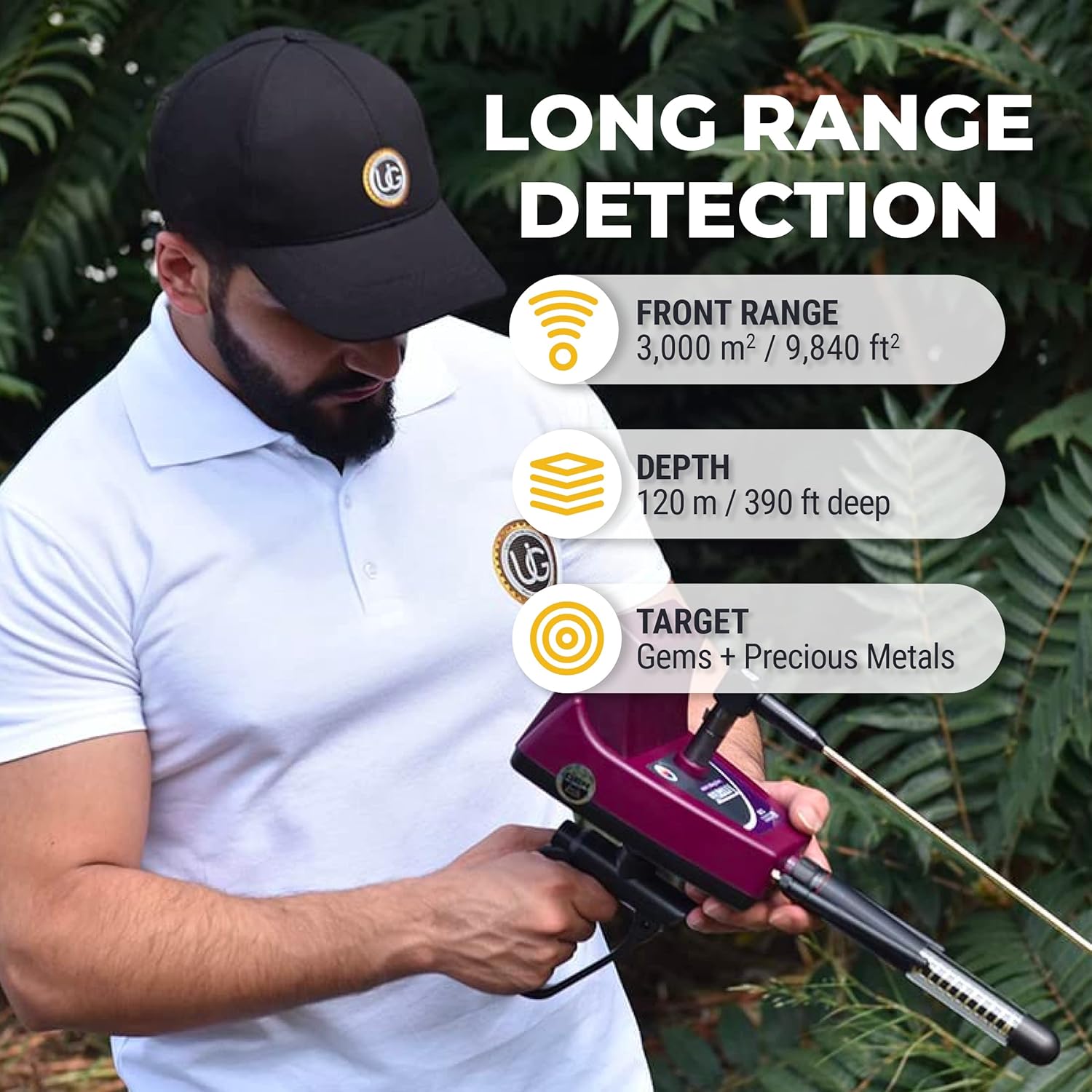
Professional Metal Detector, Highly Precise Diamond & Gemstone Locator for Long Range Detection, Latest Technology.
3. GER Detect Gold Hunter Smart Geolocator Metal Detector – Multi Systems
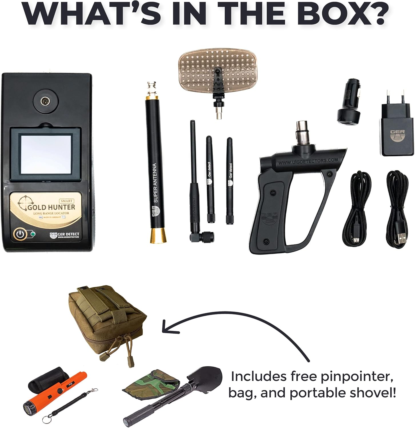
A radar-based metal detector optimized for long-range and high precision locating.
6. Hobbyist Treasure Hunting & DIY Exploration
Yes, even hobbyists are getting in on the action. While professional GPR units are expensive, entry-level models are now available for treasure hunters, metal detecting enthusiasts, and history buffs.
Imagine scanning a Civil War battlefield for unexploded ordnance or searching your backyard for old foundations or forgotten time capsules. GPR opens up a whole new world of exploration.
Just remember: Always check local laws and get permission before scanning private or protected land.
Benefits of Using GPR
Why has Ground Penetrating Radar become such a trusted tool across so many fields? The advantages are clear:
✅ Non-Invasive & Safe
No digging, no drilling, no radiation. GPR preserves surfaces and poses no health risks.
✅ Highly Accurate
Modern GPR systems can detect objects as small as a quarter-inch in diameter and pinpoint their depth within inches.
✅ Real-Time Results
Most GPR units display data instantly on a screen, allowing for immediate decision-making.
✅ Cost & Time Efficient
By preventing accidental utility strikes or structural damage, GPR saves thousands in repair costs and project delays.
✅ Versatile Applications
From concrete to soil, ice to asphalt—GPR adapts to many environments and materials.
✅ Environmentally Friendly
No chemicals, no emissions, no waste. Just clean, green technology.
For construction managers, archaeologists, and utility locators alike, GPR isn’t just a tool—it’s a risk mitigation strategy.
Limitations of GPR
While GPR is powerful, it’s not magic. Understanding its limitations is key to using it effectively.
⚠️ Soil and Ground Conditions Matter
As mentioned, clay, silt, and saltwater can severely limit signal penetration. In highly conductive soils, GPR may only reach a few inches deep.
⚠️ Depth vs. Resolution Trade-Off
Higher frequency antennas give you fine detail but shallow depth. Lower frequencies go deeper but may miss small objects.
⚠️ Operator Skill is Crucial
GPR data isn’t always easy to interpret. Without proper training, users may misread signals or miss critical features. False positives (like reading a rock as a pipe) are common for beginners.
⚠️ Cost Can Be High
Professional-grade GPR systems range from $5,000 to $50,000. While prices are dropping, it’s still a significant investment for small firms or hobbyists.
⚠️ Cannot Detect Everything
GPR struggles with very small, non-reflective, or deeply buried objects. It also can’t identify material type—only its presence and shape.
Despite these limitations, GPR remains one of the most effective underground detection tools available—especially when used alongside other methods like electromagnetic locators or magnetometers.
How to Choose the Best Ground Penetrating Radar
With so many GPR models on the market, how do you pick the right one? Here’s a practical guide to help you make an informed decision.
1. Define Your Primary Use Case
Ask yourself: What will I use GPR for most often?
- Concrete inspection? → Go for high-frequency antennas (1.5–2.6 GHz)
- Utility locating? → Mid-frequency (400–900 MHz) offers a good balance
- Deep geology or archaeology? → Low-frequency (100–300 MHz) for greater depth
2. Consider Depth Range & Resolution
- High Frequency (1–2.6 GHz): Up to 24″ depth, excellent for rebar, conduits
- Medium Frequency (400–900 MHz): 2–6 feet, ideal for pipes and cables
- Low Frequency (100–300 MHz): 10+ feet, best for deep soil layers or bedrock
3. Portability & Ease of Use
Will you be scanning indoors, on rough terrain, or in tight spaces?
- Cart-based systems: Great for large, flat areas (parking lots, roads)
- Handheld units: Better for indoor use or confined spaces
- Wearable or push-cart hybrids: Offer flexibility
4. Battery Life & Data Storage
Longer jobs need longer battery life. Look for models with:
- Hot-swappable batteries
- Onboard GPS tagging
- Cloud or USB data export
5. Software & Data Visualization
The best GPR devices come with intuitive software that:
- Generates 2D/3D images
- Allows depth slicing
- Supports annotation and reporting
6. Budget & Future-Proofing
While entry-level models start around $3,000, professional systems can exceed $20,000. Consider:
- Can the system accept multiple antenna frequencies?
- Is firmware upgradable?
- Does it offer Wi-Fi or Bluetooth?
Investing in a modular system may save money in the long run.
When to Choose High-Frequency vs. Low-Frequency GPR
| Best For | Concrete scanning, shallow utilities | Deep soil, archaeology, geology |
| Depth Range | 6–24 inches | 6–30+ feet |
| Resolution | Very high (detects small rebar) | Lower (misses fine details) |
| Surface Type | Smooth (floors, pavements) | Rough or natural terrain |
| Ideal Users | Contractors, engineers | Geologists, archaeologists |
Pro Tip: Some advanced systems allow you to swap antennas—giving you the best of both worlds.
How to Use a GPR Safely and Effectively
Even the best GPR device won’t help if you don’t use it right. Follow these tips to get accurate, reliable results.
1. Prepare the Area
- Clear debris, snow, or standing water
- Mark known surface features (manholes, valves)
- Avoid scanning near large metal objects (cars, fences)
2. Calibrate the System
- Set the correct antenna frequency
- Adjust velocity settings based on material (e.g., concrete = ~6 in/ns)
- Perform a test scan on a known object to verify accuracy
3. Use Proper Scanning Technique
- Move the unit at a steady, slow pace (2–3 mph)
- Overlap scan lines by 50% for full coverage
- Use a grid pattern for large areas
4. Interpret Data Carefully
- Look for hyperbolic (arch-shaped) reflections—common for pipes
- Watch for signal “pull-up” or “pull-down” indicating depth errors
- Compare multiple scans to confirm findings
5. Document Everything
- Save scans with GPS tags
- Annotate images with notes
- Generate reports for clients or regulatory compliance
Pro Tip: Take a training course or work with an experienced operator before relying on GPR for critical decisions.
Conclusion
Ground Penetrating Radar is more than just a tool—it’s a window into the hidden world beneath our feet. From preventing costly construction mistakes to uncovering ancient civilizations, GPR is transforming how we explore, build, and preserve.
Whether you’re a utility locator, archaeologist, engineer, or curious hobbyist, there’s a GPR solution that fits your needs. The technology is safer, faster, and more accurate than ever—making it an essential investment for anyone who works with or wonders about the subsurface.
As GPR continues to evolve—with AI-assisted interpretation, drone-mounted systems, and real-time 3D mapping—the future of underground detection is brighter than ever.
Ready to see what’s beneath your surface? Explore our top-recommended GPR devices and take the first step toward smarter, safer, and more informed exploration.
Frequently Asked Questions (FAQ)
1. What is the maximum depth GPR can detect?
It depends on soil conditions and antenna frequency. In dry, sandy soil, low-frequency GPR can reach 30+ feet. In wet clay, it may only penetrate a few inches.
2. Can GPR detect plastic pipes?
Yes! Unlike metal detectors, GPR detects changes in material density, so it can find PVC, concrete, and other non-metallic utilities.
3. Is GPR safe for humans and animals?
Absolutely. GPR uses low-power radio waves, similar to Wi-Fi. It’s non-ionizing and poses no health risks.
4. Do I need a license to operate GPR?
No formal license is required, but proper training is essential for accurate results. Many manufacturers offer certification courses.
5. Can GPR be used indoors?
Yes. High-frequency GPR is commonly used to scan concrete floors, walls, and ceilings in buildings.
6. How much does a GPR system cost?
Entry-level models start around $3,000. Professional systems range from $10,000 to $50,000 depending on features.
7. Can GPR find gold or treasure?
It can detect buried objects, but not identify material. A metal detector is better for finding gold. GPR helps map larger features like chests or tunnels.
8. How accurate is GPR depth measurement?
Typically within ±10% of actual depth, depending on correct velocity calibration and soil conditions.