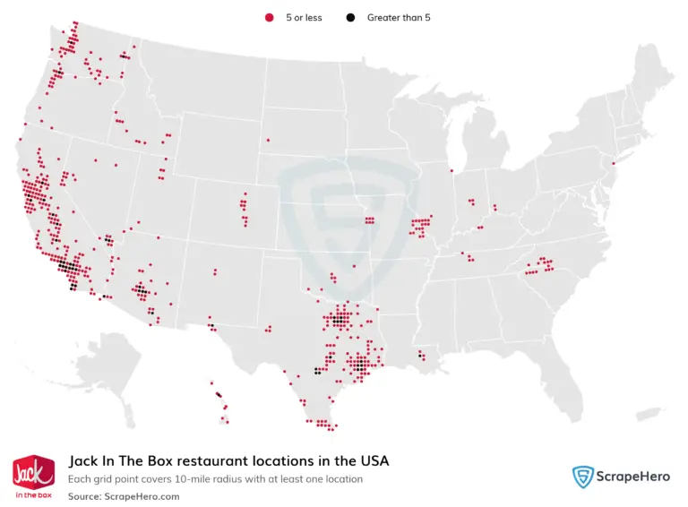
geoai-green-space-allocation

GeoAI for Smart Urban Planning – Green Space Allocation

GeoAI for Smart Urban Planning: Green Space Allocation As urban populations swell and climate change becomes more pressing, the need for sustainable, green urban environments is crucial. GeoAI has emerged as a powerful tool for addressing this issue, providing insights and data-driven strategies for effective green space allocation in our cities. Understanding GeoAI GeoAI, or…

geoai-efficient-analysis

AI in Geospatial Data Sampling – Efficient Analysis

Harnessing AI for Efficient Geospatial Data Sampling The field of geospatial analysis is experiencing a transformative shift toward efficient and effective data gathering. At the forefront of this change is Artificial Intelligence (AI), capable of analyzing vast amounts of geospatial data and intelligently selecting representative samples. This blog post explores the power of AI in…

geoai-fertilizer-optimization

GeoAI for Smart Agriculture – Fertilizer Optimization

The agricultural industry is undergoing a profound transformation driven by technological advancements, with GeoAI emerging as a game-changer. By leveraging the power of Geographic Information Systems (GIS) and artificial intelligence (AI), geoAI is revolutionizing various aspects of agriculture, aiming to optimize resource utilization and boost productivity. In this blog post, we delve into the world…

geoai-noise-reduction

AI for Geospatial Data Smoothing – Noise Reduction

AI for Geospatial Data Smoothing: Reducing Noise and Unveiling Insights Unlocking the full potential of geo-intelligence hinges on the quality of your data. Geospatial data, encompassing imagery, sensor readings, and geographic information, often suffers from noise – unwanted artifacts like pixelation, clouds, shadows, and distortions. This stands as a significant hurdle for accurate analysis and…

geoai-contaminant-detection

GeoAI for Smart Water Quality – Contaminant Detection

GeoAI for Smart Water Quality – Contaminant Detection In the quest for clean and safe water, GeoAI emerges as a crucial tool. This innovative technology leverages the power of artificial intelligence (AI) and geospatial data to enhance water quality monitoring and contaminant detection. Let’s delve into the specifics of GeoAI for smart water quality management….

geoai-data-summarization

AI in Geospatial Data Aggregation – Summarization

AI for Geospatial Data Aggregation – Summarization In the age of big data, geospatial information has become increasingly valuable. Satellites, drones, and ground sensors are constantly capturing vast amounts of geographically referenced data, covering topics ranging from urban planning to climate change monitoring. The sheer volume of information presents a significant challenge for processing, analyzing,…

geoai-public-transit-optimization

GeoAI for Smart Transportation – Public Transit Optimization

GeoAI for Smart Transportation: Public Transit Optimization The future of public transit is intelligent. Geographic Artificial Intelligence (GeoAI) is revolutionizing transportation by optimizing existing systems through advanced data analysis and predictive models. What is GeoAI? “GeoAI,” in essence, blends ground-level geographic information with artificial intelligence to analyze real-time driver behavior and patterns, traffic flow, and…

geoai-missing-data

AI for Geospatial Data Reconstruction – Missing Data

AI-Powered Geospatial Data Reconstruction: Mitigating the Impact of Missing Data Missing data in geospatial datasets is a widespread challenge, significantly hindering data analysis and decision-making in fields like environmental studies, urban planning, and resource management. Fortunately, AI emerges as a promising tool for overcoming these data limitations. Machine learning algorithms are revolutionizing geospatial data reconstruction,…

geoai-asset-tracking

GeoAI for Smart City Infrastructure – Asset Tracking

GeoAI for Smart City Infrastructure: Asset Tracking The burgeoning Smart City movement promises innovative solutions to improve urban living. At the heart of this revolution lies a critical component: optimizing infrastructure management. One area of significant progress is leveraging the power of GeoAI for asset tracking. This approach involves using Artificial Intelligence to connect physical…

geoai-data-conversion

AI in Geospatial Data Transformation – Data Conversion

# AI for Geospatial Data Transformation: The Future of Data Conversion Leveraging Artificial Intelligence for Efficient Geospatial Data Transformation Globalization of data and the increasing demand for spatial intelligence fuels the transformation of geospatial data. Geospatial data, encompassing location-based information, is essential for modern-day sectors like urban planning, transportation, resource management, and more. The challenge,…