Map of Chile Atacama Desert: Location, Geography and Why It Matters
Introduction
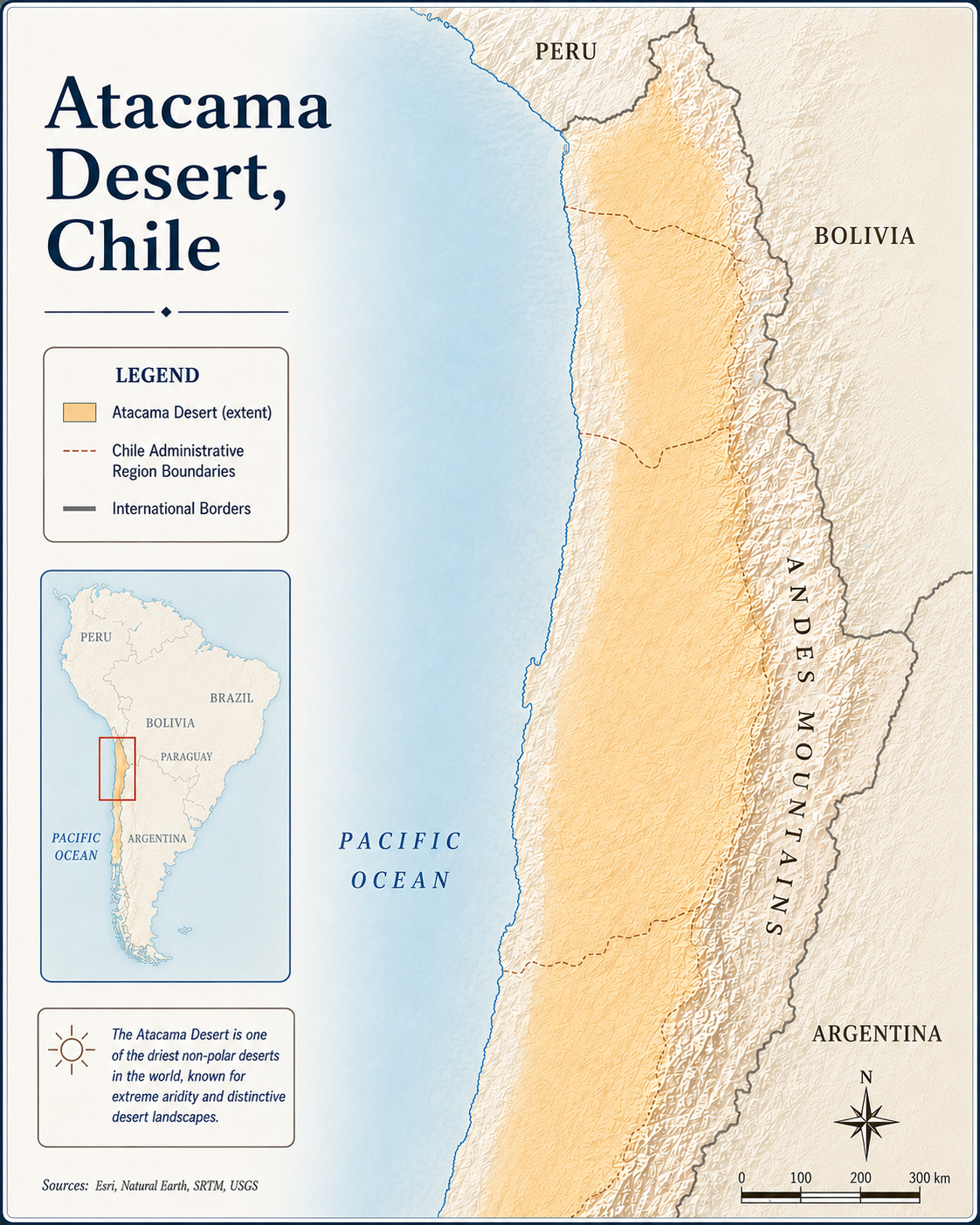
A map of Chile Atacama Desert shows one of the most unusual landscapes on Earth: a long, dry desert zone stretching across northern Chile between the Pacific Ocean and the Andes Mountains. At first glance, the Atacama may look like an empty brown strip on a map, but a closer look reveals salt flats, volcanoes, mining towns, coastal cities, astronomical observatories, ancient trade routes, and high-altitude lagoons.
For students, travelers, map lovers, and geography researchers, understanding the Atacama Desert map is the easiest way to understand why this region is so important. Its position explains its extreme dryness, its mining wealth, its famous stargazing conditions, and its role as a natural laboratory for studying Mars-like environments.
This guide explains where the Atacama Desert is located, how to read it on a Chile map, which landmarks matter most, and why the geography of the region is so unique.
Where Is the Atacama Desert on a Map of Chile?
The Atacama Desert is located in northern Chile, along the western edge of South America. On a map, Chile appears as a long, narrow country running north to south between the Pacific Ocean and the Andes Mountains. The Atacama occupies the dry northern section of this country.
The desert lies mainly across parts of these northern Chilean regions:
- Arica y Parinacota
- Tarapacá
- Antofagasta
- Atacama
Some broader geographic descriptions also connect the Atacama’s arid zones with parts of southern Peru, Bolivia’s high plateau, and northwestern Argentina. However, when most people search for a map of Chile Atacama Desert, they are usually looking for the Chilean desert belt centered around Antofagasta, Calama, San Pedro de Atacama, the Salar de Atacama, and the surrounding Andean landscapes.
Quick Map Overview
Here is the simplest way to picture the Atacama Desert on a map:
West: Pacific Ocean
East: Andes Mountains and borders near Bolivia and Argentina
North: Toward Peru and the Chilean far north
South: Toward the Atacama Region and the transition into semi-arid central Chile
Main travel hub: San Pedro de Atacama
Major nearby city: Antofagasta
Important inland city: Calama
Famous natural feature: Salar de Atacama
Famous high-altitude area: El Tatio Geysers and Andean lagoons
This north-south desert belt is not a perfect rectangle. Its boundaries vary depending on whether the map is showing climate zones, political regions, tourist routes, geology, or ecological landscapes.

Why the Atacama Desert Is So Dry
The Atacama Desert is famous for being one of the driest places on Earth. Its dryness is not random; it is caused by geography. A map helps explain the desert’s extreme climate.
Three major factors shape the region:
1. The Andes Mountains Block Moisture
To the east, the Andes form a massive mountain barrier. Moist air from the Amazon side of South America has difficulty crossing these mountains. By the time air reaches the Atacama side, it has lost much of its moisture.
2. The Pacific Coast Has Cool Ocean Influence
To the west, the Pacific Ocean borders the desert. The cold ocean current along the coast helps create stable, dry atmospheric conditions. Instead of producing regular rain, the coast often experiences fog and dry air.
3. The Desert Lies in a Rain Shadow
The Atacama is trapped between major geographic barriers: the coastal side of Chile and the Andes. This rain shadow effect helps create one of the most arid landscapes on the planet.
When you look at a physical map of the Atacama Desert, you can see why moisture struggles to reach the area. The desert is squeezed between ocean, mountains, high plateaus, and dry interior basins.
Key Places to Find on an Atacama Desert Map
A useful Atacama Desert map should show more than the desert’s outline. The following places help explain the region’s geography, tourism, science, and economy.
1. San Pedro de Atacama
San Pedro de Atacama is one of the most important towns on the tourist map of northern Chile. It is a small desert oasis located near the Salar de Atacama and surrounded by volcanoes, valleys, salt flats, and high-altitude landscapes.
Many travelers use San Pedro as a base for visiting:
- Valle de la Luna
- Salar de Atacama
- Laguna Cejar
- El Tatio Geysers
- Altiplanic lagoons
- Puritama hot springs
- Stargazing sites
On a map, San Pedro de Atacama sits inland, southeast of Calama and close to Chile’s borders with Bolivia and Argentina.
2. Antofagasta
Antofagasta is a major coastal city in northern Chile. It sits on the Pacific coast and is one of the most important urban centers connected to the Atacama Desert.
On a Chile desert map, Antofagasta is useful because it shows the relationship between the coastal desert and the inland mining and highland zones. The city is also historically linked to mining, ports, and transportation across northern Chile.
3. Calama
Calama is an inland city northeast of Antofagasta and west of San Pedro de Atacama. It is one of the main access points for travelers heading into the desert interior.
Calama is also close to major mining areas, including some of Chile’s most important copper-producing zones. On a map, Calama often appears as a key connection point between the coast, mining districts, and San Pedro de Atacama.
4. Salar de Atacama
The Salar de Atacama is one of the most important features on any map of the Atacama Desert. A salar is a salt flat, and this one is among the largest and most famous in Chile.
The Salar de Atacama is located south of San Pedro de Atacama. It includes salt crusts, lagoons, flamingo habitats, and mineral-rich basins. It is also important because of lithium extraction, making it a major location in discussions about clean energy, batteries, and environmental management.
5. Valle de la Luna
Valle de la Luna, or Valley of the Moon, is a dramatic desert landscape near San Pedro de Atacama. On tourist maps, it is usually marked west of San Pedro.
The area is known for rock formations, salt ridges, dunes, and moonlike scenery. It is one of the most visited sites in the Atacama because it is close to town and easy to include in a short travel route.
6. El Tatio Geysers
El Tatio is a high-altitude geothermal field northeast of San Pedro de Atacama. On a map, it appears in the Andean zone, much higher than the desert floor.
The geysers are best known for steam columns, geothermal activity, and cold early-morning conditions. Their location shows how the Atacama is not only a desert but also part of an active volcanic and geothermal landscape.
7. Atacama Observatories
The Atacama Desert is one of the world’s best regions for astronomy. Its high altitude, dry air, and clear skies make it ideal for observatories.
Important astronomy-related sites in or near the wider Atacama region include:
- ALMA Observatory
- Paranal Observatory
- Cerro Tololo area farther south
- Other high-altitude telescope sites across northern Chile
On a map, these observatories are often located away from major cities to reduce light pollution and take advantage of dry, stable air.
How to Read a Map of the Chile Atacama Desert
Different maps show the Atacama in different ways. To understand the region better, choose the right type of map for your purpose.

Political Map
A political map shows country borders, regional boundaries, cities, towns, and roads. This is useful for identifying Chile’s northern regions and nearby countries such as Peru, Bolivia, and Argentina.
Use a political map to find:
- Antofagasta
- Calama
- San Pedro de Atacama
- Copiapó
- Iquique
- Arica
- Chile’s borders with Bolivia, Argentina, and Peru
Physical Map
A physical map shows mountains, valleys, rivers, salt flats, plateaus, and elevation. This is the best type of map for understanding why the Atacama is so dry.
Use a physical map to identify:
- Andes Mountains
- Chilean Coastal Range
- Salar de Atacama
- Volcanoes
- High-altitude lagoons
- Desert basins
- Pacific coastline
Road Map
A road map is best for travel planning. It shows highways, smaller roads, towns, fuel stops, and distances.
Important road connections include:
- Calama to San Pedro de Atacama
- Antofagasta to Calama
- San Pedro de Atacama to nearby desert attractions
- Routes toward the Chile-Bolivia border
Satellite Map
A satellite map is excellent for seeing the real color and texture of the desert. From above, the Atacama shows salt flats, volcanic cones, dry valleys, mining areas, and rugged mountain terrain.
Satellite imagery is especially useful for students and researchers because it reveals landforms that may not be obvious on a standard road map.
3D View of Atacama Desert
Atacama Desert and the Shape of Chile
Chile’s shape is one of the most recognizable in the world. It is extremely long from north to south but very narrow from east to west. This shape matters because the Atacama Desert is part of Chile’s northern geographic identity.
The desert is located where Chile is bordered by:
- The Pacific Ocean to the west
- The Andes Mountains to the east
- Peru and Bolivia to the north and northeast
- Argentina across the Andes to the east
This location gives the Atacama its unusual combination of coastal fog, inland dryness, high mountains, salt flats, and volcanoes.
Why the Atacama Desert Matters
The Atacama Desert is not just a blank dry zone on a map. It is important for science, travel, mining, ecology, and climate studies.
1. It Is a Natural Geography Classroom
The Atacama helps explain rain shadows, ocean currents, mountain barriers, desert basins, and high-altitude ecosystems. Few places show the link between maps and climate as clearly as northern Chile.
2. It Supports Major Mineral Resources
Northern Chile is globally important for mining, especially copper and lithium. Maps of the Atacama often show mining districts, transport routes, salt flats, and industrial zones.
3. It Is a Global Astronomy Hub
Because of its dry air and clear skies, the Atacama is home to some of the world’s most important observatories. A map of observatory locations shows how scientists use geography to study space.
4. It Contains Unique Ecosystems
Although the Atacama is extremely dry, it is not lifeless. Fog-fed plants, salt-flat lagoons, flamingos, desert flowers, and highland wildlife all exist in specific zones. A good ecological map can show where life survives in this extreme environment.
5. It Attracts Travelers From Around the World
The Atacama is one of Chile’s most famous travel regions. Visitors come for landscapes, photography, stargazing, archaeology, hiking, and desert road trips.
Suggested 3-Day Atacama Map Route
For travelers using a map of the Chile Atacama Desert, San Pedro de Atacama is the easiest base for a short route.
Day 1: San Pedro de Atacama and Valle de la Luna
Start in San Pedro. Explore the town, then travel west to Valle de la Luna for desert formations and sunset viewpoints.
Day 2: Salar de Atacama and Lagoons
Head south toward the Salar de Atacama. Visit salt-flat lagoons and look for flamingos in protected wetland areas.
Day 3: El Tatio Geysers and Highlands
Travel northeast before sunrise to El Tatio. Continue exploring high-altitude landscapes, villages, and Andean viewpoints.
This route shows why maps are essential in the Atacama: distances are large, elevations change quickly, and many attractions are spread across remote desert and mountain terrain.
Map Tips for Students and Travelers
When studying or visiting the Atacama Desert, keep these map tips in mind:
- Always check scale because distances in northern Chile are larger than they appear.
- Use elevation maps because altitude changes can affect travel time and weather.
- Look for salt flats, volcanoes, and basins to understand the physical geography.
- Compare political and physical maps to see how borders and landforms interact.
- For travel, download offline maps before leaving towns because remote areas may have limited signal.
- Do not rely only on a simple tourist sketch map for long-distance driving.
Best Image Alt Text Ideas for SEO
Use descriptive alt text if publishing maps or photos in the article. Good examples include:
- “Map of Chile Atacama Desert showing northern Chile and the Andes Mountains”
- “Atacama Desert map with San Pedro de Atacama and Salar de Atacama”
- “Physical map of northern Chile showing the Atacama Desert”
- “Satellite view of the Atacama Desert in Chile”
- “Tourist map of San Pedro de Atacama and nearby desert attractions”
These alt tags help search engines understand the image while also improving accessibility for readers using screen readers.
FAQ About the Map of Chile Atacama Desert
Where is the Atacama Desert located?
The Atacama Desert is located in northern Chile, along the Pacific side of South America. It lies mainly between the Pacific Ocean and the Andes Mountains.
What country is the Atacama Desert in?
The Atacama Desert is mainly in Chile. Some broader arid landscapes connected to the Atacama extend toward neighboring areas of Peru, Bolivia, and Argentina, but the most famous part is in northern Chile.
What is the closest major town to the Atacama Desert attractions?
San Pedro de Atacama is the main tourist base for many popular desert attractions, including Valle de la Luna, Salar de Atacama, El Tatio Geysers, and nearby lagoons.
Why is the Atacama Desert so dry?
The Atacama is dry because of its position between the Andes Mountains, the Pacific coastal zone, and large-scale atmospheric patterns. The Andes block moisture from the east, while the Pacific coast helps maintain dry conditions.
What should a good Atacama Desert map include?
A good map should include northern Chile, the Pacific Ocean, Andes Mountains, San Pedro de Atacama, Calama, Antofagasta, Salar de Atacama, major roads, volcanoes, and border areas near Bolivia and Argentina.
Is the Atacama Desert good for stargazing?
Yes. The Atacama is one of the best stargazing regions in the world because of its high altitude, dry air, and clear skies. This is why several major observatories are located in northern Chile.
Conclusion
A map of Chile Atacama Desert is more than a location guide. It explains why northern Chile is dry, why the region contains salt flats and volcanoes, why astronomers build observatories there, and why travelers use San Pedro de Atacama as a gateway to some of South America’s most dramatic landscapes.
By reading political, physical, road, and satellite maps together, you can understand the Atacama as a complete geographic system: ocean to the west, Andes to the east, desert basins in between, and some of the clearest skies on Earth above.
For anyone studying Chile, planning a trip, or learning about deserts, the Atacama Desert map is one of the best examples of how geography shapes climate, settlement, science, and human activity.