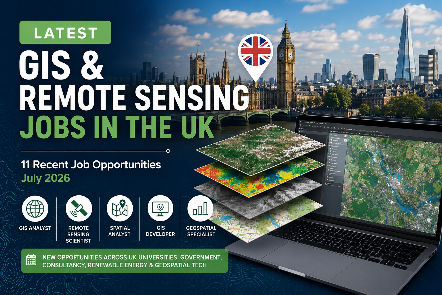
11 Recent GIS and Remote Sensing Jobs in the UK – Summer 2026
Table of Contents
The United Kingdom continues to offer diverse employment opportunities for GIS analysts, remote-sensing scientists, geospatial developers, spatial researchers and enterprise GIS specialists.
The vacancies in this selection cover several sectors, including environmental consulting, higher education, renewable energy, maritime navigation, heritage management, atmospheric science and enterprise geospatial technology.
Some positions focus mainly on traditional GIS analysis and cartography, while others require advanced knowledge of Python, remote sensing, ArcGIS Enterprise, FME, cloud platforms, artificial intelligence or scientific data analysis.
This list was reviewed on 22 July 2026. Applicants should always confirm the closing date and availability on the official employer page before preparing an application, as some employers may close vacancies early.
Quick comparison of current UK geospatial vacancies
| Position | Employer | Location | Salary | Contract | Closing date |
|---|---|---|---|---|---|
| Online Tutor – GIS & Remote Sensing | Ulster University | Remote within the UK | £32.46 per hour | Part-time register | 23 July 2026 |
| Research Fellow in African Heritage, Remote Sensing and GIS | University College London | London, hybrid | £42,261 per year | Full-time, fixed term | 26 July 2026 |
| Geospatial Platform Operations Manager | The Crown Estate | London, hybrid | Not disclosed | Full-time | 29 July 2026 |
| Senior GIS Consultant | Mott MacDonald | London, Leeds, Liverpool or Manchester | Not disclosed | Permanent, full-time | 31 July 2026 |
| Lead Geospatial Specialist – Geodesy and PNT | UK Hydrographic Office | Taunton, Somerset | £48,746 per year | Full-time | 3 August 2026 |
| Atmospheric Remote Sensing Scientist | University of Leeds | Leeds | £51,753–£59,966 per year | Full-time, ongoing | 10 August 2026 |
| Research Associate in Atmospheric Dynamics | University of Bath | Bath | £38,784–£46,049 per year | Full-time, fixed term | 11 August 2026 |
| Research Fellow in Geospatial Mapping and Analysis | University of Southampton | Southampton | £36,636–£41,064 per year | Full-time, fixed term | 17 August 2026 |
| Senior Lecturer in Spatial and Statistical Analysis | University of York | York | £58,225–£67,468 per year | Permanent, full-time | 27 August 2026 |
| Geospatial Platform Lead | Lightsource bp | London | Competitive, not disclosed | Permanent | Not stated |
| Full Stack GIS Developer | Informed Solutions | Altrincham, Leeds or London, hybrid | Not disclosed | Full-time | Not stated |
1. Online Tutor – GIS and Remote Sensing
Employer: Ulster University
Location: Remote, with duties performed from within the UK
Salary: £32.46 per hour
Closing date: 23 July 2026
Job type: Part-time tutor register
Ulster University is recruiting online tutors to support its postgraduate programmes in Geographic Information Systems and Remote Sensing.
This opportunity may be particularly suitable for GIS professionals, researchers, university lecturers and PhD holders who have specialist knowledge and want to gain or expand their online teaching experience.
Potential responsibilities include delivering online academic support, assessing student work, marking assignments, providing feedback, moderating assessments and possibly supervising postgraduate projects.
The university states that the tutor register will remain available until 31 December 2030. However, being accepted onto the register does not guarantee a specific number of teaching hours.
Candidates must be able to perform their duties from within the United Kingdom. The advertised rate is £32.46 per hour.
Relevant skills:
- GIS and spatial analysis
- Remote-sensing principles
- Online teaching and student support
- Academic assessment and feedback
- Postgraduate project supervision
View the Ulster University vacancy and apply
2. Research Fellow in African Heritage, Remote Sensing and GIS
Employer: University College London
Location: London, with hybrid working
Salary: £42,261 per year, including London Allowance
Closing date: 26 July 2026
Job type: Full-time, fixed term until 30 June 2029
University College London is recruiting a Research Fellow to work on the Mapping Africa’s Endangered Archaeological Sites and Monuments project, commonly known as MAEASaM.
The position involves applying remote sensing, GIS, historical maps, documentary sources and field-based verification to identify and document endangered archaeological sites across sub-Saharan Africa.
This is an interdisciplinary opportunity combining geospatial technology with archaeology, cultural heritage and environmental monitoring. The successful candidate will work within the UCL Institute of Archaeology and contribute to a major international research programme.
The position is expected to involve satellite-image interpretation, geospatial database management, mapping, research publication and collaboration with researchers and heritage institutions.
The role is full-time at 36.5 hours per week and is funded until 30 June 2029. The advertised salary is £42,261 per year, including London Allowance.
Relevant skills:
- Satellite remote sensing
- Archaeological or heritage GIS
- Spatial database management
- Historical-map analysis
- Research writing and publication
- Field-data verification
View the UCL vacancy and apply
3. Geospatial Platform Operations Manager
Employer: The Crown Estate
Location: 1 St James’s Market, London
Working arrangement: Hybrid
Salary: Not disclosed
Closing date: 29 July 2026
Job type: Full-time
The Crown Estate is seeking an experienced professional to manage and improve its enterprise geospatial platform.
The platform supports decision-making across a highly diverse portfolio covering urban property, rural land, the coastline, the seabed, offshore wind, marine infrastructure and the Windsor Estate.
The successful applicant will oversee the reliability, security and performance of the organization’s enterprise GIS environment. The person will also manage incidents, coordinate upgrades, support users and work with technical teams and vendors to develop the platform.
This position is most appropriate for an experienced enterprise GIS administrator or geospatial operations manager rather than an entry-level GIS analyst.
Essential technologies listed in the vacancy include ArcGIS Enterprise, ArcGIS Online, enterprise geodatabases hosted in Azure SQL, FME Flow, FME Form, Microsoft Azure and ArcGIS Pro. SQL, Python, R, Databricks and Power BI are considered desirable.
Relevant skills:
- ArcGIS Enterprise administration
- ArcGIS Online administration
- Enterprise geodatabases
- Microsoft Azure
- FME Flow and FME Form
- Platform security and troubleshooting
- SQL and Python
- Stakeholder and vendor management
View the Crown Estate vacancy and apply
4. Senior GIS Consultant
Employer: Mott MacDonald
Locations: Manchester, London, Liverpool or Leeds
Working arrangement: Hybrid and agile working
Salary: Not disclosed
Closing date: 31 July 2026
Job type: Permanent, full-time
Mott MacDonald is recruiting a Senior GIS Consultant to support major infrastructure and environmental projects in the United Kingdom.
The successful candidate will lead GIS services on complex projects, manage spatial datasets, coordinate project resources and design geospatial solutions that improve project delivery and decision-making.
The role goes beyond desktop map production. It includes workflow automation, spatial analytics, data integration, mobile data collection, technical review, business development and mentoring junior colleagues.
Applicants should have substantial experience with ArcGIS Pro, ArcGIS Online or Portal for ArcGIS and spatial-data management. The vacancy also values experience with Python, SQL, R, JavaScript, Arcade, FME and web GIS development.
Mott MacDonald states that applications may close before the official deadline when a high number of applications is received. The employer also indicates that Skilled Worker visa sponsorship is not currently available for this position.
Relevant skills:
- ArcGIS Pro
- ArcGIS Online and Portal for ArcGIS
- Spatial analysis and data management
- Python, SQL, R or JavaScript
- FME
- Web GIS development
- Mobile field-data collection
- Project and team management
View the Mott MacDonald vacancy and apply
5. Lead Geospatial Specialist – Geodesy and PNT
Employer: UK Hydrographic Office
Location: Taunton, Somerset
Salary: £48,746 per year
Closing date: 3 August 2026 at 11:55 p.m.
Job type: Full-time Civil Service position
The UK Hydrographic Office is recruiting a Lead Geospatial Specialist with expertise in geodesy and positioning, navigation and timing, or PNT.
The UKHO produces navigational products and geospatial information used by the maritime community. Its geodesy team helps ensure that hydrographic and navigational products are positioned accurately.
The selected specialist will provide technical leadership, develop innovative solutions and support emerging operational requirements. The person will work with geodesy, remote-sensing and tides specialists and may provide technical guidance across the Ministry of Defence, government organizations and the wider maritime sector.
This opportunity is particularly relevant for experienced geodesists, hydrographers, geomatics engineers and positioning specialists.
The advertised salary is £48,746 per year. Applicants should review the Civil Service nationality rules and any security-clearance requirements associated with the position.
Relevant skills:
- Geodesy and reference systems
- Positioning, navigation and timing
- Hydrographic data
- Geospatial quality assurance
- Coordinate transformations
- Technical leadership
- Maritime geospatial information
View the UK Hydrographic Office vacancy and apply
6. Atmospheric Remote Sensing Scientist
Employer: University of Leeds and National Centre for Atmospheric Science
Location: Leeds Main Campus
Salary: £51,753–£59,966 per year
Closing date: 10 August 2026
Job type: Full-time, ongoing
The University of Leeds is recruiting an Atmospheric Remote Sensing Scientist to provide scientific leadership for the National Centre for Atmospheric Science’s emerging Cloud and Boundary Layer Observatory.
The successful candidate will work with advanced atmospheric-observation systems, including dual-frequency cloud radar. Responsibilities include observatory design, radar-science development, data-product creation, scientific research and engagement with the wider atmospheric-science community.
The role requires advanced expertise in atmospheric observations, radar remote sensing or a related scientific field. It is likely to suit candidates with substantial postdoctoral or professional research experience.
The position is offered at Grade 8, with an advertised salary of £51,753–£59,966 per year.
Relevant skills:
- Atmospheric remote sensing
- Cloud radar
- Boundary-layer observations
- Scientific programming
- Atmospheric-data processing
- Research publication
- Observatory or instrument development
View the University of Leeds vacancy and apply
7. Research Associate in Atmospheric Dynamics
Employer: University of Bath
Location: Bath
Salary: £38,784–£46,049 per year
Closing date: 11 August 2026
Job type: Full-time, fixed term for two years
The University of Bath is recruiting a Research Associate to work on the Leverhulme Trust-funded Seeing the Unseen project.
The project investigates atmospheric gravity waves and their influence on weather, climate, atmospheric circulation and potentially tropical-cyclone intensification.
The researcher will analyse observations from NASA and European Space Agency satellites alongside ground-based measurements and high-resolution atmospheric simulations.
Applicants should have completed, or be close to completing, a PhD in atmospheric science, meteorology, physics, mathematics or a related discipline. Experience in satellite retrievals, remote sensing, high-resolution atmospheric modelling or atmospheric dynamics would be particularly valuable.
The position is a full-time, two-year appointment with a salary starting at £38,784 and rising to £46,049.
Relevant skills:
- Satellite remote sensing
- Atmospheric dynamics
- Meteorological-data analysis
- NASA and ESA Earth-observation data
- Scientific programming
- Numerical atmospheric modelling
- Research software development
View the University of Bath vacancy and apply
8. Research Fellow in Geospatial Mapping and Analysis
Employer: University of Southampton
Location: Boldrewood Campus, Southampton
Salary: £36,636–£41,064 per year
Closing date: 17 August 2026
Job type: Full-time, fixed term for 24 months
The University of Southampton is recruiting a postdoctoral Research Fellow to develop geospatial decision-support tools for offshore-wind planning.
The research focuses on spatial planning and cumulative-effects assessment in the Greater North Sea Basin. The successful candidate will collect, process and harmonize multidisciplinary geospatial datasets covering offshore engineering, marine ecology, archaeology and coastal communities.
The researcher will also contribute to the development of an integrated geospatial database and apply artificial-intelligence models to spatial analysis.
Applicants should have a PhD or equivalent professional qualification in a relevant discipline, such as geography, oceanography, marine science, engineering, geology or archaeology. Advanced GIS experience is essential, while knowledge of offshore renewable energy is desirable.
The initial contract is for 24 months, with the possibility of extension to 36 months. The salary range is £36,636–£41,064 per year.
Relevant skills:
- Advanced GIS analysis
- Geospatial database development
- Offshore-wind spatial planning
- Marine and environmental data
- Artificial intelligence for geospatial analysis
- Decision-support tools
- Multidisciplinary spatial-data integration
View the University of Southampton vacancy and apply
9. Senior Lecturer in Spatial and Statistical Analysis
Employer: University of York
Location: York
Salary: £58,225–£67,468 per year
Closing date: 27 August 2026
Job type: Permanent, full-time
The University of York is recruiting a Senior Lecturer in Spatial and Statistical Analysis within its Department of Environment and Geography.
This is the highest-paying vacancy in this selection for which a numerical salary range has been published.
The role combines academic research, teaching, postgraduate supervision, research leadership and external funding development. The successful candidate will contribute expertise in spatial analysis, GIS, quantitative methods and statistical modelling.
Applicants should normally hold a PhD or possess equivalent professional experience. A strong academic publication record, teaching experience and the ability to develop competitive research proposals are likely to be important.
The advertised salary is £58,225–£67,468 per year, and the position is listed as open by the university.
Relevant skills:
- Spatial statistics
- GIS and spatial modelling
- Quantitative environmental analysis
- Academic teaching
- Postgraduate supervision
- Research publication
- Research-funding applications
View the University of York vacancy and apply
10. Geospatial Platform Lead
Employer: Lightsource bp
Location: London
Salary: Competitive, but the numerical amount is not disclosed
Closing date: Not stated
Job type: Permanent
Lightsource bp is recruiting a Geospatial Platform Lead to manage the organization’s enterprise geospatial environment and lead a team of GIS professionals.
The company develops renewable-energy and energy-storage projects. Its geospatial platform supports activities related to site development, engineering, environmental assessment, planning and asset management.
The successful applicant will lead geospatial projects, administer enterprise GIS systems, design automated workflows and integrate GIS technology with other corporate systems.
Applicants should have at least seven years of experience in geospatial technologies, ideally within renewable energy, infrastructure, environmental management or a related industry.
The technical requirements include ArcGIS Pro, ArcSDE, Portal for ArcGIS, FME, ArcPy and Python. Knowledge of cloud infrastructure and enterprise-system integration is also valuable.
Lightsource bp advertises a competitive salary alongside benefits that include an annual bonus, pension, health insurance and a retention scheme.
Relevant skills:
- ArcGIS Enterprise
- ArcGIS Pro and ArcSDE
- Portal for ArcGIS
- FME
- ArcPy and Python
- Cloud-based GIS
- Renewable-energy project development
- Team and project leadership
View the Lightsource bp vacancy and apply
11. Full Stack GIS Developer
Employer: Informed Solutions
Locations: Altrincham, Leeds or London
Working arrangement: Hybrid
Salary: Not disclosed
Closing date: Not stated
Job type: Full-time
Informed Solutions is recruiting a Full Stack GIS Developer to design and deliver geospatial digital services.
The position combines GIS development with full-stack software engineering. It is suitable for professionals who can work across spatial databases, web applications, APIs, cloud environments and geospatial services.
The successful candidate will contribute to digital solutions for complex operational and public-sector challenges. Depending on the project, the work may include spatial-data processing, application development, cloud deployment, system integration and user-focused service design.
Relevant technologies may include Java, .NET, Python, web APIs, cloud platforms and enterprise GIS tools.
This position may appeal to GIS developers who want to move beyond desktop analysis into geospatial software engineering and digital-service development. The official vacancy is listed as hybrid and full-time, with possible bases in Altrincham, London and Leeds.
Relevant skills:
- Full-stack application development
- Web GIS
- Java, .NET or Python
- APIs and system integration
- Spatial databases
- Cloud deployment
- Geospatial service architecture
- Agile digital delivery
View the Informed Solutions vacancy and apply
Which jobs offer the highest salaries?
Among the vacancies that disclose a numerical salary, the highest advertised ranges are:
- Senior Lecturer in Spatial and Statistical Analysis: £58,225–£67,468 per year.
- Atmospheric Remote Sensing Scientist: £51,753–£59,966 per year.
- Lead Geospatial Specialist – Geodesy and PNT: £48,746 per year.
- Research Associate in Atmospheric Dynamics: £38,784–£46,049 per year.
- Research Fellow in African Heritage, Remote Sensing and GIS: £42,261 per year.
- Research Fellow in Geospatial Mapping and Analysis: £36,636–£41,064 per year.
- Online Tutor in GIS and Remote Sensing: £32.46 per hour.
Several private-sector employers do not publish a salary range. Candidates may therefore need to ask about compensation during the initial recruitment process.
Salary should not be considered in isolation. Pension contributions, annual leave, bonuses, health insurance, hybrid working, relocation support and professional-development opportunities can substantially affect the overall value of an employment package.
Skills appearing most frequently in these vacancies
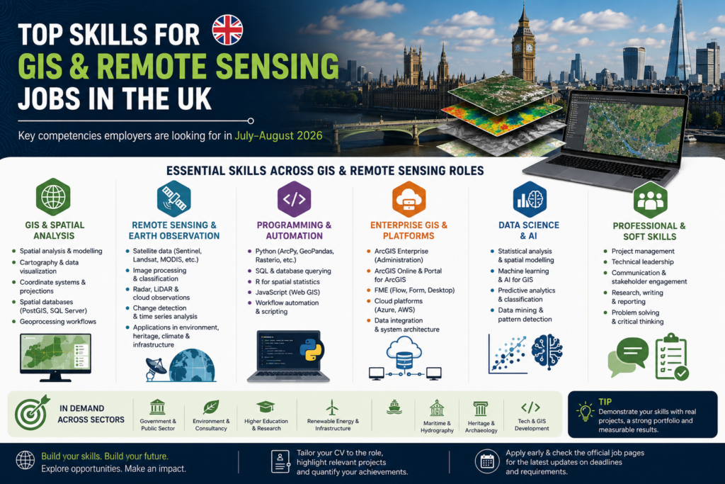
The requirements across these positions show that employers are looking for more than basic map-production skills.
ArcGIS Enterprise and cloud GIS
Senior commercial positions increasingly require experience administering ArcGIS Enterprise, ArcGIS Online, Portal for ArcGIS and enterprise geodatabases.
Candidates seeking enterprise GIS positions should understand platform architecture, authentication, security, service publishing, database connections, backups, upgrades and system monitoring.
Python and workflow automation
Python appears repeatedly across consultancy, renewable-energy and enterprise-platform roles.
GIS professionals should be able to demonstrate how they have used Python, ArcPy, GeoPandas or related libraries to automate repetitive processes, improve data quality or create reproducible spatial-analysis workflows.
FME and data integration
FME is particularly important in positions involving engineering, infrastructure, environmental management and enterprise data.
Experience creating FME workspaces for data conversion, validation, transformation and system integration can provide a strong advantage.
Remote sensing and Earth observation
Academic opportunities emphasize satellite data, atmospheric observations, radar, archaeological remote sensing and environmental analysis.
Candidates should clearly identify the sensors, satellite missions and processing methods they have used. Examples may include Sentinel, Landsat, MODIS, commercial imagery, cloud radar, NASA datasets and ESA Earth-observation products.
Spatial statistics and artificial intelligence
Several positions combine GIS with statistics, machine learning or artificial intelligence.
Applicants should highlight experience with spatial regression, classification, clustering, predictive modelling, uncertainty analysis, geospatial AI and decision-support systems.
Communication and project management
Senior GIS positions require the ability to communicate with non-specialists, manage client expectations, define technical requirements and coordinate multidisciplinary teams.
A technically strong application should therefore also demonstrate leadership, documentation, presentation and stakeholder-management abilities.
How to prepare a stronger GIS job application
Adapt your CV to the position
Avoid sending exactly the same CV to every employer.
A remote-sensing research position requires a different emphasis from an enterprise GIS administrator or geospatial developer position. Reorder your experience and skills according to the vacancy.
For an enterprise GIS role, highlight ArcGIS Enterprise, databases, cloud infrastructure, FME and platform administration.
For a scientific remote-sensing role, emphasize satellite datasets, research methods, programming, publications and scientific results.
For a GIS developer role, focus on software projects, APIs, web applications, version control, automated testing and cloud deployment.
Include measurable achievements
Instead of writing that you “used GIS to analyse environmental data,” explain the scale and result of the work.
For example:
Automated a spatial-data validation workflow using Python and FME, reducing weekly processing time from six hours to forty minutes.
A measurable statement helps an employer understand the practical value of your experience.
Create a geospatial portfolio
A portfolio is especially useful for GIS analysts, cartographers, remote-sensing specialists and developers.
It can include:
- Web maps and dashboards
- Python notebooks
- GitHub projects
- Story maps
- Remote-sensing classifications
- Spatial-analysis reports
- Automated geoprocessing tools
- Database or system-architecture diagrams
- Before-and-after examples of improved map design
Do not publish confidential employer or client data. Replace sensitive information with public or simulated datasets.
Address the essential criteria directly
Many UK employers evaluate applications against a formal list of essential and desirable criteria.
Use the same terminology as the vacancy when it accurately describes your experience. Provide a short example demonstrating each important requirement rather than simply listing software names.
Check work-authorization conditions
Applicants based outside the United Kingdom should carefully review sponsorship and eligibility information.
Some employers may sponsor international applicants, while others explicitly state that Skilled Worker sponsorship is unavailable. Civil Service positions may also be subject to nationality and security-clearance rules.
Never assume that an employer offers sponsorship simply because the application form accepts international addresses.
Apply before the final day
Some commercial employers close vacancies early after receiving enough applications. Applying several days before the deadline reduces the risk of missing the opportunity.
Candidates should also allow enough time to prepare supporting statements, research proposals, portfolios and references.
Final thoughts
These vacancies demonstrate the diversity of the UK geospatial employment market. Current opportunities range from online GIS teaching and academic research to geodesy, enterprise-platform management, offshore-wind planning, atmospheric remote sensing and full-stack geospatial development.
Professionals with a combination of GIS fundamentals, programming, data management and domain-specific knowledge are particularly well positioned for these roles.
Before applying, carefully compare your experience with the essential criteria, adapt your CV and supporting statement, and confirm that the vacancy remains open on the employer’s official recruitment page.
Last reviewed: 22 July 2026
Disclaimer: TechGeo.org is not affiliated with the employers listed in this article. Job details, salaries, working arrangements and closing dates may be changed by the employer. Always verify the latest information through the official vacancy page before submitting an application.