Map Of Italy with Regions and Main Cities: Complete Geography Guide
Table of Contents
Introduction
A Map Of Italy with Regions and Main Cities is one of the best ways to understand the geography, culture, and political structure of Italy. Shaped like a boot and stretching into the Mediterranean Sea, Italy is divided into 20 regions, each with its own identity, history, landscapes, cuisine, and major urban centers.
From the Alpine north to the islands of Sicily and Sardinia, Italy’s regional map reveals how diverse the country really is. Cities such as Rome, Milan, Naples, Turin, Florence, Venice, Bologna, Palermo, and Genoa are not only important population centers but also major hubs for history, art, trade, tourism, education, and transportation.
This guide explains Italy’s regions, their capitals, and the most important cities to know when reading or using a map of Italy.
Understanding the Map of Italy
Italy is located in Southern Europe and is surrounded by the Mediterranean Sea. It shares land borders with France, Switzerland, Austria, and Slovenia. Within Italy’s territory are also two independent microstates: Vatican City and San Marino.
On a map, Italy is usually divided into three broad geographic areas:
Northern Italy — known for the Alps, major industrial cities, lakes, and economic centers such as Milan and Turin.
Central Italy — home to Rome, Florence, Tuscany, Umbria, and important historic landscapes.
Southern Italy and the Islands — including Naples, Bari, Calabria, Sicily, and Sardinia, known for coastlines, ancient ruins, agriculture, and Mediterranean culture.
A detailed Map Of Italy with Regions and Main Cities helps identify not only where each region is located but also how major cities connect across the country.
Italy’s 20 Regions and Their Capitals
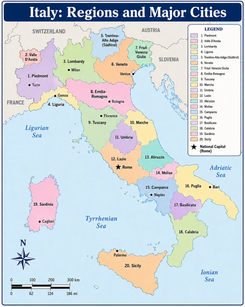
Italy is divided into 20 administrative regions. Each region has a capital city, and several regions contain other major cities that are important for tourism, business, education, or transportation.
| No. | Region | Capital | Main Cities |
|---|---|---|---|
| 1 | Abruzzo | L’Aquila | Pescara, Teramo, Chieti |
| 2 | Aosta Valley | Aosta | Courmayeur, Saint-Vincent |
| 3 | Apulia | Bari | Lecce, Taranto, Foggia, Brindisi |
| 4 | Basilicata | Potenza | Matera, Melfi |
| 5 | Calabria | Catanzaro | Reggio Calabria, Cosenza, Crotone |
| 6 | Campania | Naples | Salerno, Caserta, Benevento |
| 7 | Emilia-Romagna | Bologna | Parma, Modena, Ravenna, Rimini |
| 8 | Friuli Venezia Giulia | Trieste | Udine, Pordenone, Gorizia |
| 9 | Lazio | Rome | Latina, Viterbo, Frosinone |
| 10 | Liguria | Genoa | La Spezia, Savona, Sanremo |
| 11 | Lombardy | Milan | Bergamo, Brescia, Como, Monza |
| 12 | Marche | Ancona | Pesaro, Urbino, Macerata |
| 13 | Molise | Campobasso | Isernia, Termoli |
| 14 | Piedmont | Turin | Novara, Alessandria, Asti |
| 15 | Sardinia | Cagliari | Sassari, Olbia, Nuoro |
| 16 | Sicily | Palermo | Catania, Messina, Syracuse |
| 17 | Trentino-Alto Adige/Südtirol | Trento | Bolzano, Merano, Rovereto |
| 18 | Tuscany | Florence | Pisa, Siena, Lucca, Livorno |
| 19 | Umbria | Perugia | Terni, Assisi, Spoleto |
| 20 | Veneto | Venice | Verona, Padua, Vicenza, Treviso |
Northern Italy on the Map
Northern Italy is the country’s most industrialized and economically powerful area. It includes regions such as Lombardy, Piedmont, Veneto, Emilia-Romagna, Liguria, Trentino-Alto Adige/Südtirol, Friuli Venezia Giulia, and Aosta Valley.
Lombardy
Lombardy is one of Italy’s most important regions. Its capital, Milan, is a global center for fashion, finance, design, technology, and business. On a map, Lombardy is located in northern Italy, close to Switzerland.
Main cities in Lombardy include Milan, Bergamo, Brescia, Como, Monza, and Pavia. The region is also known for Lake Como, Lake Garda, and the Po Valley.
Piedmont
Piedmont lies in northwestern Italy, bordering France and Switzerland. Its capital is Turin, a city known for automotive history, elegant architecture, museums, and Alpine access.
Other important cities include Novara, Alessandria, Asti, and Cuneo. Piedmont is also famous for wine regions, mountain landscapes, and historic towns.
Veneto
Veneto is located in northeastern Italy. Its capital is Venice, one of the world’s most famous cities. Venice is built on a lagoon and is known for canals, bridges, historic palaces, and cultural heritage.
Other major cities in Veneto include Verona, Padua, Vicenza, and Treviso. Verona is famous for its Roman arena, while Padua is known for its university and religious sites.
Emilia-Romagna
Emilia-Romagna stretches across northern Italy and is one of the country’s most important agricultural, culinary, and industrial regions. Its capital is Bologna.
Major cities include Parma, Modena, Ravenna, Rimini, Ferrara, and Reggio Emilia. The region is famous for food, universities, motorsport, beaches, and medieval city centers.
Liguria
Liguria is a narrow coastal region in northwestern Italy along the Ligurian Sea. Its capital is Genoa, an important port city with a long maritime history.
Other cities include La Spezia, Savona, Imperia, and Sanremo. Liguria is also known for the Italian Riviera and the colorful coastal villages of Cinque Terre.
Central Italy on the Map
Central Italy contains some of the country’s most famous cultural and historical regions, including Lazio, Tuscany, Umbria, and Marche. This area is especially important for travelers because it includes Rome and Florence.
Lazio
Lazio is located in central Italy and has Rome as its capital. Rome is also the capital of Italy and one of the most historically significant cities in the world.
A map of Lazio shows Rome near the western coast, connected to other cities such as Latina, Viterbo, Frosinone, and Rieti. Vatican City is located within Rome, making the region especially important for religious and cultural tourism.
Tuscany
Tuscany is one of Italy’s most recognizable regions. Its capital, Florence, is famous for Renaissance art, architecture, museums, and historic landmarks.
Other important Tuscan cities include Pisa, Siena, Lucca, Livorno, Arezzo, and Grosseto. Tuscany is also known for rolling hills, vineyards, medieval towns, and scenic countryside.
Umbria
Umbria is a landlocked region in central Italy. Its capital is Perugia, a historic hilltop city known for universities, art, and chocolate.
Other important cities include Terni, Assisi, Spoleto, and Orvieto. Umbria is often called the “green heart of Italy” because of its forests, hills, and rural landscapes.
Marche
Marche is located along the Adriatic coast in central Italy. Its capital is Ancona, a port city with important ferry connections and coastal views.
Main cities include Pesaro, Urbino, Macerata, Fermo, and Ascoli Piceno. Marche combines beaches, mountains, Renaissance towns, and agricultural valleys.
Southern Italy on the Map
Southern Italy includes Campania, Apulia, Basilicata, Calabria, Molise, and Abruzzo. This part of the country is known for coastal cities, ancient settlements, dramatic landscapes, and strong regional traditions.
Campania
Campania is one of southern Italy’s most famous regions. Its capital is Naples, a major city located near Mount Vesuvius and the Bay of Naples.
Other important cities include Salerno, Caserta, Benevento, and Avellino. Campania is home to Pompeii, the Amalfi Coast, Capri, and some of Italy’s best-known culinary traditions.
Apulia
Apulia, also called Puglia, forms the “heel” of Italy’s boot-shaped peninsula. Its capital is Bari, an important port city on the Adriatic Sea.
Major cities include Lecce, Taranto, Foggia, Brindisi, and Andria. Apulia is known for whitewashed towns, olive groves, coastal landscapes, and unique architecture such as the trulli houses of Alberobello.
Calabria
Calabria forms the “toe” of Italy’s boot. Its regional capital is Catanzaro, while Reggio Calabria is one of its largest and most important cities.
Other cities include Cosenza, Crotone, and Vibo Valentia. Calabria is known for rugged mountains, beaches, traditional villages, and views across the Strait of Messina toward Sicily.
Abruzzo
Abruzzo is located east of Rome and stretches from the Apennine Mountains to the Adriatic Sea. Its capital is L’Aquila.
Main cities include Pescara, Teramo, and Chieti. Abruzzo is known for national parks, mountain towns, wildlife, and Adriatic beaches.
Basilicata
Basilicata is a smaller southern region located between Campania, Apulia, and Calabria. Its capital is Potenza.
The region’s most famous city is Matera, known for its ancient cave dwellings and historic stone districts. Basilicata is mountainous, quiet, and rich in cultural heritage.
Molise
Molise is one of Italy’s smallest and least populated regions. Its capital is Campobasso.
Other important towns include Isernia and Termoli. Molise is known for rural landscapes, mountains, small villages, and Adriatic coastline.
Sicily and Sardinia on the Map
Italy’s two largest islands are Sicily and Sardinia. Both are autonomous regions with distinct histories, landscapes, and cultures.
Sicily
Sicily is the largest island in the Mediterranean Sea. Its capital is Palermo, located on the island’s northern coast.
Other major cities include Catania, Messina, Syracuse, Trapani, and Agrigento. Sicily is famous for Mount Etna, ancient Greek temples, beaches, historic cities, and a unique blend of Mediterranean cultures.
Sardinia
Sardinia is located west of mainland Italy. Its capital is Cagliari, situated on the southern coast.
Other important cities include Sassari, Olbia, Nuoro, and Oristano. Sardinia is known for clear waters, beaches, mountains, ancient archaeological sites, and distinctive local traditions.
Autonomous Regions of Italy
Five Italian regions have special autonomous status. These regions have greater administrative powers because of historical, linguistic, cultural, or geographic reasons.
The five autonomous regions are:
- Aosta Valley
- Friuli Venezia Giulia
- Sardinia
- Sicily
- Trentino-Alto Adige/Südtirol
These regions are important to recognize on a Map Of Italy with Regions and Main Cities because several have strong linguistic diversity, island geography, or borderland cultures.
Main Cities of Italy to Know
While each region has its own capital, some cities stand out as especially important on a national map.
Rome
Rome is the capital of Italy and the capital of Lazio. It is the country’s political center and one of the most visited cities in the world. Famous landmarks include the Colosseum, Roman Forum, Pantheon, and Vatican City.
Milan
Milan is the capital of Lombardy and one of Europe’s leading business and fashion centers. It is a major transportation hub and an important city for finance, design, media, and technology.
Naples
Naples is the capital of Campania and one of southern Italy’s largest cities. It is known for its historic center, coastal location, food culture, and proximity to Pompeii and Mount Vesuvius.
Turin
Turin is the capital of Piedmont. It is known for industry, museums, historic squares, and its location near the Alps.
Florence
Florence is the capital of Tuscany and a major center of Renaissance art and architecture. It is one of Italy’s most important cultural cities.
Venice
Venice is the capital of Veneto. Built across islands and canals, it is one of the most unique urban landscapes in the world.
Bologna
Bologna is the capital of Emilia-Romagna. It is famous for its university, porticoes, food culture, and central location in northern Italy.
Palermo
Palermo is the capital of Sicily. It is an important cultural and historic city with Arab-Norman architecture, markets, churches, and coastal scenery.
Genoa
Genoa is the capital of Liguria and one of Italy’s most important port cities. It has a rich maritime history and a large historic center.
Bari
Bari is the capital of Apulia and a major city on the Adriatic Sea. It is an important transport, commercial, and cultural center in southern Italy.
Why a Map of Italy with Regions and Main Cities Is Useful
A regional map of Italy is useful for many purposes. Travelers can use it to plan routes between major cities, students can use it to learn Italian geography, and researchers can use it to understand regional patterns.
A good Italy map helps users:
- Identify all 20 regions of Italy
- Locate regional capitals
- Understand north, central, and southern Italy
- Find major cities and transport hubs
- Compare mainland Italy with Sicily and Sardinia
- Learn how geography influences culture, climate, and economy
For example, a traveler planning a trip from Milan to Venice can see that both cities are in northern Italy, while someone visiting Rome, Florence, and Naples can understand how central and southern routes connect.
Best Ways to Read a Map of Italy
When reading a Map Of Italy with Regions and Main Cities, start by locating the country’s major geographic zones.
First, find the Alps in the north. This area borders France, Switzerland, Austria, and Slovenia. Then move south through the Po Valley, where cities such as Milan, Turin, Bologna, and Venice are located.
Next, look at central Italy, where Rome and Florence are found. Finally, follow the peninsula south toward Naples, Apulia, Calabria, and the island of Sicily.
Sardinia is located west of the mainland, separated by the Tyrrhenian Sea. Sicily is located southwest of Calabria, across the Strait of Messina.
Italy Map for Travel Planning
For travel planning, Italy’s regional map is especially helpful because many popular destinations are grouped by region.
In northern Italy, travelers often visit Milan, Lake Como, Venice, Verona, Bologna, and the Italian Riviera. In central Italy, popular destinations include Rome, Florence, Pisa, Siena, and Assisi. In southern Italy, major travel areas include Naples, the Amalfi Coast, Bari, Matera, Calabria, Sicily, and Sardinia.
Using a map helps travelers avoid confusion because many famous destinations are not close together. For example, Venice and Naples are in very different parts of the country, while Florence and Pisa are both in Tuscany.
Italy Map for Students
Students learning geography can use a map of Italy to memorize the 20 regions and their capitals. A useful method is to divide the country into sections:
North: Aosta Valley, Piedmont, Lombardy, Trentino-Alto Adige/Südtirol, Veneto, Friuli Venezia Giulia, Liguria, Emilia-Romagna
Center: Tuscany, Umbria, Marche, Lazio
South: Abruzzo, Molise, Campania, Apulia, Basilicata, Calabria
Islands: Sicily, Sardinia
This makes it easier to understand the country’s layout and remember where each region is located.
FAQ About the Map of Italy with Regions and Main Cities
How many regions are there in Italy?
Italy has 20 regions. Each region has its own capital city and local administrative structure.
What is the capital of Italy?
The capital of Italy is Rome. Rome is also the capital of the Lazio region.
What are the main cities in Italy?
The main cities in Italy include Rome, Milan, Naples, Turin, Florence, Venice, Bologna, Palermo, Genoa, and Bari.
Which region is Milan in?
Milan is located in the Lombardy region in northern Italy.
Which region is Venice in?
Venice is located in the Veneto region in northeastern Italy.
Which region is Florence in?
Florence is located in Tuscany, one of central Italy’s most famous regions.
What are the two main islands of Italy?
The two largest islands of Italy are Sicily and Sardinia. Both are also autonomous regions.
What is the largest region in Italy?
Sicily is the largest region by area and is also the largest island in the Mediterranean Sea.
Which Italian regions have special autonomous status?
The five autonomous regions of Italy are Aosta Valley, Friuli Venezia Giulia, Sardinia, Sicily, and Trentino-Alto Adige/Südtirol.
Conclusion
A Map Of Italy with Regions and Main Cities is essential for understanding the country’s geography, travel routes, culture, and administrative divisions. Italy’s 20 regions each have their own capital, identity, and major cities, making the country one of the most geographically and culturally diverse places in Europe.
From Milan in Lombardy to Rome in Lazio, from Florence in Tuscany to Naples in Campania, and from Palermo in Sicily to Cagliari in Sardinia, every part of Italy offers something unique. Whether you are studying geography, planning a trip, or exploring Italy’s regional structure, a detailed map of Italy provides a clear and useful overview of the country.